
The Met Office has pinned down exactly where snow will fall on the first day of 2026, as the agency has issued a yellow weather warning in the region. For tens of thousands of people in the UK, the new year is starting as a white one, with as much as 20cm of snow forecast to cause disruption while the mercury plummets to a biting -4C.
High ground in the north of Scotland is set to be the worst hit with the warning covering areas in Central, Tayside and Fife, Grampian, Highlands and Eilean Siar, Orkney and Shetland, and Strathclyde. The national forecaster says frequent and heavy snow showers could lead to travel disruption and wintry hazards throughout the first week of January.
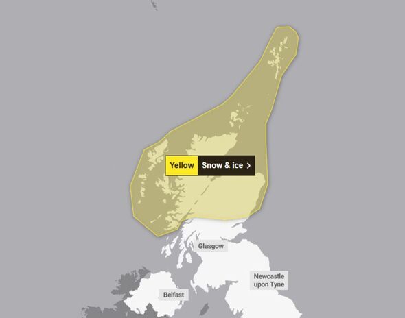
They added: "Disruption to travel is likely on roads, with some stranded vehicles and passengers, along with delayed or cancelled rail and air travel. There is a slight chance that some rural communities could become cut off."
The agency also warned that the Arctic blast could cause power cuts and disruption to mobile phone coverage.
Met Office Deputy Chief Forecaster Mark Sidaway said: "It certainly looks like we are in for a taste of 'winter' as we welcome in the New Year, initially in the north, but more widely across the UK for the first week of 2026.
"Arctic air and strong northerly winds will bring cold or very cold conditions to all parts of the UK, and it will feel especially cold in the strong winds. Widespread and locally severe frosts are expected, along with the first snow of the winter for many.

"A yellow warning for snow and ice has been issued for northern Scotland on New Year's Day and beyond, where frequent and heavy snow showers may lead to some travel disruption.
"These colder conditions and wintry hazards - snow, ice and strong winds - will develop more widely as we enter the New Year, with more warnings for snow and ice likely. It looks like this cold spell will last through at least the first week of January, so it's important people keep up to date with the latest forecast and warnings."
The snow and ice alert is in force from 6am on Thursday, January 1, until 11.59pm on Friday, January 2.
The forecasters have predicted that 10-20 cm is possible over many areas, with 30 cm or more on higher routes and hills. On the lower ground, 2-5cm of lying snow could build early on Friday morning before lingering into the evening.
-
Harry Brook Creates History, Becomes Fastest Batter In The World To...

-
Vegan Demands Roommate Stop Having Non-Vegan Food To Respect Her ‘Boundaries’

-
Vegan Demands Roommate Stop Having Non-Vegan Food To Respect Her ‘Boundaries’

-
5 Zodiac Signs With The Very Best Horoscopes On December 30, 2025

-
The Simple Rubber Band Trick That Can Remove A Stripped Screw