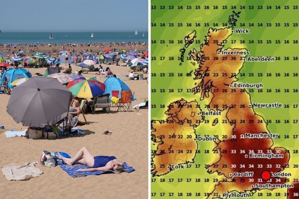

The UK is set to continue its trend of above-average sweltering temperatures this summer, with the hottest day of year ushering in yet another heatwave just days later. Parts of the country will see forecasts shoot up to 34C in mid-July, less than a fortnight after Brits were warned about highs of 36C on June 30 - a threshold that would make it the hottest day of the year so far and among the hottest ever recorded in June. The heatwave that has gripped Britain since last week is expected to peak on Monday, June 30, before gradually falling to around 25C by the end of the week.
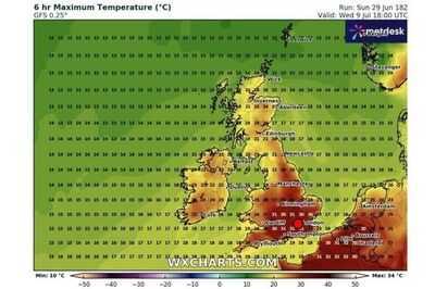
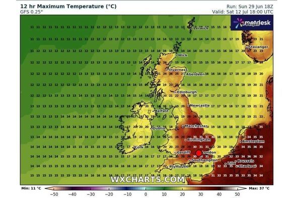
While temperatures will remain above average in areas including Manchester, Sheffield, Bristol and Cambridge, the temporary drop in the mercury won't last long. New weather maps from WXCharts show southeast England sweltering from around 6pm on Wednesday, July 9, reaching 31C in Greater London, Sussex, Surrey and Hampshire, before rising to around 34C days later.
Temperatures in Scotland and northern England are forecast to hover around 20C on July 9, growing warmer on the eastern coast, with Lincolnshire expected to see highs of around 26C.
It could be a similar story for the southwest, with the mercury rising to 31C in Dorset and Somerset and shooting to 27C in Wales and the West Midlands on Wednesday evening.
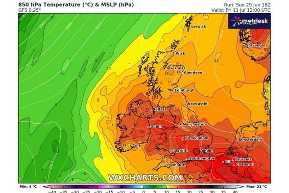
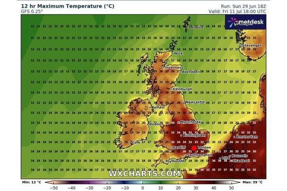
The weather will get even hotter towards mid-July, with maps from WCharts showing sky-high temperatures of 34C across a huge stretch of the country, from the East Sussex coast right up to the tip of Derbyshire on Friday, July 11.
The heatwave is also predicted to spread across more of the UK throughout next month, with parts of northern Scotland rising to 26C by the weekend of July 12 and 13.
Experts have sounded the alarm about the health impact of heatwaves, especially on vulnerable people, since temperatures began to climb in early June, warning that the climate-change weather phenomena are "silent killers".
Amber heat health alerts for Yorkshire and the Humber, East Midlands, West Midlands, eastern England, London, the southeast and the southwest have been extended into Wednesday morning, July 2.
Paul Gunderson, the Met Office's chief meteorologist, said: "These higher temperatures and humid conditions will be quite uncomfortable for those working outside, as well as people leaving Glastonbury and attending the start of Wimbledon, and other outdoor events.
"Stay hydrated and try to keep out of the sun during the hottest part of the day."
Today:
Hot and sunny across England and Wales with rain possible later in the day, especially in the north and east. Cooler temperatures in the northwest.
Tonight:
Dry, sunny and humid for most of the country, with some cloud and and drizzle in Scotland, northern England and parts of Wales.
Tuesday:
Continued humid and muggy temperatures in the southeast, with some rain possible. Sunny in the northwest and cloudy with a chance of rainfall elsewhere.
Outlook for Wednesday to Friday:
Less humidity with some rain expected, especially on Wednesday and Friday. Temperatures expected to remain above average.
-
Turkey hotel issues scathing statement as mum arrested for 'worst mistake of her life'

-
Supreme Court declines to hear RFK Jr.'s anti-vax group complaint over social media censorship

-
Indore: MGM Medical College Lab Tops Madhya Pradesh In Quality Certification
-
Katie Boulter was 'bricking it completely' before upsetting Paula Badosa at Wimbledon

-
Filming starts for Meryl Streep-starrer 'The Devil Wears Prada 2'