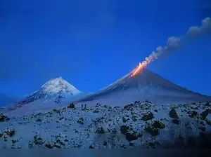
Lava flows down the western slope of Russia’s Klyuchevskoy volcano after a powerful eruption in Kamchatka — the largest active volcano in the Northern Hemisphere.
Photo credit: X : Valentín Varillas
Russia's Kamchatka Peninsula is currently experiencing an unprecedented convergence of natural disasters, with a powerful earthquake, a volcanic eruption, and a tsunami all unfolding within hours of each other.
On Wednesday, the Klyuchevskoy volcano, one of Eurasia's tallest and most active, erupted just hours after a massive 8.8-magnitude earthquake struck off the Kamchatka coast. According to Russia’s Geological Survey, the volcano began spewing lava and ash, with glowing lava seen flowing down its western slope and explosive activity reported at the crater. “The Klyuchevskoy is erupting right now,” the agency confirmed via Telegram, sharing images of the eruption.
The earthquake, which struck near Avacha Bay, around 125 km southeast of Petropavlovsk-Kamchatsky, triggered widespread tsunami warnings across the Pacific. The tremor occurred at a shallow depth of 20 km, amplifying its potential to displace water and cause sea surges.
Tsunami alerts were issued for parts of Russia, Japan, the United States, Canada, New Zealand, and the Philippines.
The earthquake also caused significant structural damage in Kamchatka. Buildings shook violently in Petropavlovsk-Kamchatsky, a city of nearly 180,000 people, leading to building collapses, power outages, and communication breakdowns. Emergency teams reported several people needing medical attention. The Kuril Islands, particularly Severo-Kurilsk, saw tsunami activity that forced residents to evacuate to safer locations.
Geologists have recorded several strong aftershocks, some reaching magnitude 6.9, and warn that seismic activity could persist for weeks. Authorities continue to monitor the situation closely, urging the public to stay alert and avoid high-risk areas.
Why Kamchatka?
The Kamchatka Peninsula, situated in Russia’s Far East, lies along the Pacific Ring of Fire, a seismically volatile zone where the Pacific Plate subducts beneath the Okhotsk Microplate at around 86 mm/year. This tectonic activity makes the region highly prone to earthquakes, volcanic eruptions, and tsunamis.
Kamchatka is home to over 160 volcanoes, with 29 still active. It has a long history of megathrust quakes, including one in 1952 (magnitude 9.0) that sent waves as far as Hawaii, and an even stronger quake in 1737 estimated at magnitude 9.3. The region also experienced notable seismic chains in 2006 and 2017, and a massive mudslide in 2007.
This latest triple threat underscores the region’s extreme geological volatility and the challenges of disaster preparedness in one of the world’s most dynamic natural hotspots.


