At 21% above normal, North India is witnessing its wettest monsoon since 2013—the year of the devastating Kedarnath flash floods. Alarmingly, August has seen the region log the highest number of ‘extremely heavy’ rainfall events since the India Meteorological Department (IMD) began tracking this metric in 2021, reported ToI.
However, according to the weather agency data, India has received 2% more rainfall than normal so far, but extremes stand out -Meghalaya faces a 43% deficit, while Rajasthan (38%) and Ladakh (192%) report surpluses.
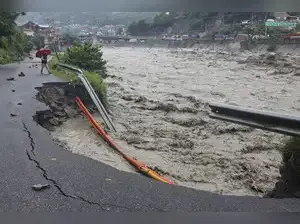
Most destructive August in years
Till August 25, north India had logged 21 extremely heavy rain events, a 50% rise over the previous highest of 14 recorded last year, even though that month had registered higher rainfall, according to a TOI report. The number of such events is likely to rise further by the end of the month, making this Aug's monsoon among the most destructive in the region in recent years.

This monsoon, North India stands out as the only region among the country’s four to record a rainfall surplus in all three months—June, July, and August—marking the first such instance since 2013.
"In the last two months, northwest India (IMD nomenclature for north India) has seen high rainfall activity mainly because of frequent interactions between western disturbances and monsoon currents from Bay of Bengal and sometimes from Arabian Sea. When these two currents meet over the region, a lot of rain takes place," Mrutyunjay Mohapatra, IMD chief told TOI.
The extreme rainfall data for the region reveals that while Aug last year had more 'heavy' (64.4-115.5mm) and 'very heavy' (115.5-204.4mm) rain events, it recorded far less number of 'extremely heavy' rainfall episodes than Aug this year. Last year, north India had reported its wettest month of Aug in 28 years since 1996, with the region as a whole logging 256.4mm of rain. The current month has so far (till Aug 26) reported 209.4mm, with five days still to go.
However, according to the weather agency data, India has received 2% more rainfall than normal so far, but extremes stand out -Meghalaya faces a 43% deficit, while Rajasthan (38%) and Ladakh (192%) report surpluses.
Most destructive August in years
Till August 25, north India had logged 21 extremely heavy rain events, a 50% rise over the previous highest of 14 recorded last year, even though that month had registered higher rainfall, according to a TOI report. The number of such events is likely to rise further by the end of the month, making this Aug's monsoon among the most destructive in the region in recent years.This monsoon, North India stands out as the only region among the country’s four to record a rainfall surplus in all three months—June, July, and August—marking the first such instance since 2013.
"In the last two months, northwest India (IMD nomenclature for north India) has seen high rainfall activity mainly because of frequent interactions between western disturbances and monsoon currents from Bay of Bengal and sometimes from Arabian Sea. When these two currents meet over the region, a lot of rain takes place," Mrutyunjay Mohapatra, IMD chief told TOI.
The extreme rainfall data for the region reveals that while Aug last year had more 'heavy' (64.4-115.5mm) and 'very heavy' (115.5-204.4mm) rain events, it recorded far less number of 'extremely heavy' rainfall episodes than Aug this year. Last year, north India had reported its wettest month of Aug in 28 years since 1996, with the region as a whole logging 256.4mm of rain. The current month has so far (till Aug 26) reported 209.4mm, with five days still to go.