Cities across England and Wales look set for gusts of wind pushing 60mph as a monstrous storm is forecast to batter Britain. The Met Office has issued a yellow warning for wind, covering the two home nations from 8pm on Sunday to 6pm on Monday (September 14-15).
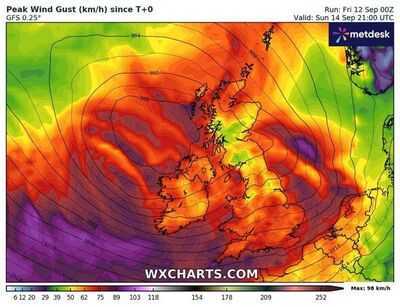
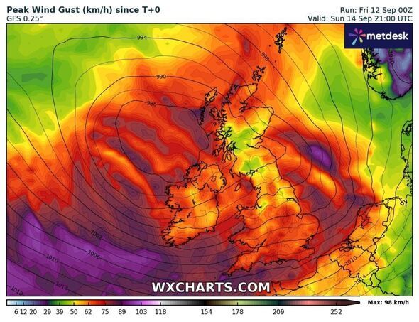
The national forecaster warns of transport delays, large waves and power cuts as strong west to southwesterly winds arrive along the coasts of southwest England and Wales before spreading inland. Gusts of 45-55mph are expected inland, with gusts of 60-70mph possible at times along exposed coasts and hills.
Cities under the warning area include York, Leeds, Hull, Manchester, Chester, St Asaph, Sheffield, Liverpool, Lincoln, Bangor, Stoke-on-Trent, Nottingham, Swansea, Cardiff, St Davids, Birmingham, Coventry, Wolverhampton, Hereford, Worcester, Gloucester, Leicester, Peterborough, Norwich, Cambridge, Oxford, Milton Keynes, St Albans, Chelmsford, London, Canterbury, Brighton, Portsmouth, Southampton, Salisbury, Bath, Bristol, Wells, Exeter, Plymouth and Truro.
The Met Office has advised people in the warning area to prepare by protecting their property including the securing of loose items outside properties such as bins, sheds, fences and garden furniture.
Paul Gundersen, Chief Meteorologist at the Met Office, said on Thursday that a named storm was unlikely. He added: "We have been monitoring a deepening area of low pressure over the North Atlantic that might bring impactful weather to the UK, most likely on Sunday and Monday."
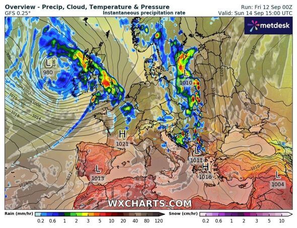
Weather maps generated by WX Charts on Friday, September 12, show rain across almost the whole country at 3pm on the coming Sunday, with the heaviest in the north of England and Bristol Channel coasts.
A second map shows peak wind gusts across England, Wales and Northern Ireland between 60-75kmh (37-46mph) at 9pm on Sunday, according to WX Charts.
Met Office spokesman Graham Madge said on Friday morning there is no intention to name a storm as of now.
He said: "Obviously we are in meteorological autumn now, it's the sort of weather that we do expect at this time of year.
"So it's nothing unusual, particularly - perhaps it's just the contrast with the weather that we have enjoyed over most of the summer."
Mr Madge said another system is also developing which could bring severe gales to exposed coastal locations on Wednesday.
The spokesman said this will have less of an impact than Sunday and Monday's weather front, adding it is too early to tell where it will impact.
Met Office UK five day weather forecastFriday, September 12 to Tuesday, September 16
Friday began with brightness in the east, but cloudy skies prevailed elsewhere. Scattered showers spill eastwards through the day. These will be heavy with a risk of thunder. It will be cool and breezy for all, but especially in the north.
Tonight showers will gradually fade bringing a dry night for many, though they will linger in the west. Some will be heavy and merge into longer spells of rain. Under clear skies it will feel cool.
Saturday is another day of sunny spells and scattered, blustery showers, with the heaviest and most frequent in the west. It turns drier in the south through the evening, but remains breezy for all.
It will be wet and windy on Sunday with coastal gales possible across the southwest. Blustery showers will continue through Monday, before turning more settled on Tuesday as winds and showers ease.
-
Missed the September 15 ITR Deadline? Here's What Penalties and Risks You Could Face in 2025

-
Missed the September 15 ITR Deadline? Here's What Penalties and Risks You Could Face in 2025
-
Weeds will disappear 'overnight' with simple 30p trick

-
Weeds will disappear 'overnight' with simple 30p trick
-
10 Jobs That Artificial Intelligence Cannot Replace, According to Microsoft Report