Downpours and winds of more than 50mph are expected to hit the UK this weekend, possibly causing damage. Weather maps predictabrutal storm is on its way and will batter the country on Sunday, so much so that the Met Office has issued a yellow wind warning.
People have been speculating whether the storm will be named Storm Amy. It has not received an official name as of yet, but the Met Office has confirmed Amy will be the first name to be used for the 2025/2026 season. Naming is done by the Met Office to aid in communication when a storm has the potential to cause disruption or damage, which could result in an amber or red warning.
The weather agency said the storm was most likely to hit on Sunday into Monday. Deputy chief Meteorologist Tom Crabtree said: "We are keeping an eye on a deepening area of low-pressure which will develop over the North Atlantic during the coming days and might bring impactful weather to the UK, most likely on Sunday and Monday."
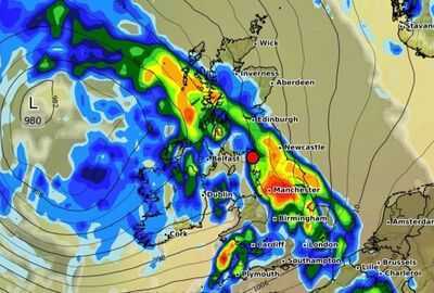
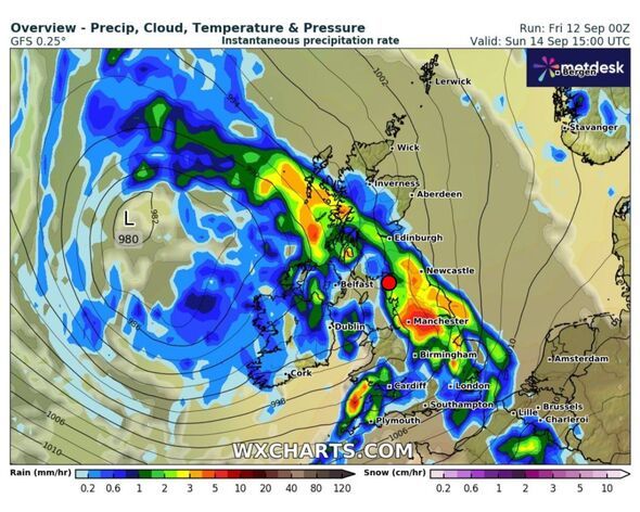
Forecaster WXCharts is expecting the storm to arrive at 12pm, hitting Northern Ireland, Wales, and southwest England. By 3pm, Scotland and the rest of England will be hit, with the heaviest rain across the north of England (Manchester, Sheffield, Newcastle). A yellow warning for wind has also been issued from 8pm on Sunday (September 14) to 6pm Monday (September 15), covering Wales, the southwest of England, and the south coast, with gusts of 70-80mph possible along exposed coasts.
The Met Office forecast for the rest of the week says: "Friday will be breezy, with showers feeding into western coastal areas overnight before becoming more widespread during the day. These showers may be heavy in places, with isolated thunderstorms likely and some merging into more organised bands of rain.
"Stronger winds and coastal gales are possible. The driest conditions and best of any sunshine will be found in the east, though temperatures will remain on the cool side."
Paul Gundersen, chief meteorologist at the Met Office, said: "We have been monitoring a deepening area of low-pressure over the North Atlantic that might bring impactful weather to the UK, most likely on Sunday and Monday. At present, a named storm is unlikely."
Today: A bright start in the east, however cloudy skies will prevail elsewhere with scattered showers readily spilling eastwards through the day, these heavy and carrying a risk of thunder. Cool and breezy for all, but most especially in the north.
Tonight: Showers will gradually fade bringing a dry night for many, although showers will linger in the west. Some heavy, merging into longer spells of rain. Feeling cool beneath clear skies.
Saturday: Another day of sunny spells and scattered, blustery showers, these heaviest and most frequent in the west. Turning drier in the south through the evening, though remaining breezy for all.
Outlook for Sunday to Tuesday: Widely wet and windy on Sunday with coastal gales possible across the southwest. Further blustery showers through Monday, before turning more settled from Tuesday with winds and showers easing.
-
CBI Conducts Raids in Gujarat Over ₹121 Crore Bank Fraud Case

-
India backs UN resolution for two-state solution in Palestine

-
India, EU maximising efforts to finalise FTA negotiations by year end

-
SC allows release of Rs.5,000 cr to Sahara investors; extends deadline

-
Telangana’s SCCL to diversify into thermal, solar, green energy: Vikramarka