
Bhubaneswar: India Meteorological Department (IMD) Director General Mrutyunjay Mohapatra on Sunday clarified that the low pressure brewing over Bay of Bengal, which is expected to turn into a depression, is unlikely to have any direct impact on Odisha.
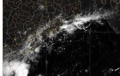
According to the MeT office, a low-pressure area may form over southeast Bay of Bengal around October 21 under the influence of a cyclonic circulation over south Andaman Sea & adjoining southeast Bay of Bengal. The system is likely to move west-northwestwards and intensify further into a depression over central parts of south Bay of Bengal and adjoining westcentral Bay of Bengal during the subsequent 48 hours.
Mohapatra said that no warning has been issued for Odisha. He, however, said that fishermen should avoid venturing into South and Central Bay of Bengal during this period. “Those in the sea should return to the shore at the earliest,” he added.
The Depression is likely to move across Tamil Nadu-south Andhra Pradesh coasts. “The possible low-pressure system, moving in the west-north-west direction, may come close to the Andhra Pradesh-Tamil Nadu coast by October 23/24. The system may cross the coast close to Kakinada in central Andhra Pradesh, but it is too early to make any prediction on its path and strength. Under its influence, rain may occur in Odisha but the possibility of direct impact is low,” said meteorologist Abhijeet Sahoo.
According to weather models, including NCEP, ECMWF, ECAI, IMD GFS, GEFS, and BFS, the low-pressure may form between October 20 and 21 and strengthen into a depression between October 22 and 23.
The models suggest that the system will move west-northwestwards towards the Andhra Pradesh-North Tamil Nadu coast.
Some models, particularly the GFS group, have indicated at further intensification of the system.. However, the IMD’s Multi-Model Ensemble (MME) shows that the system may continue as a depression and make landfall around October 24 along the South Andhra Pradesh-North Tamil Nadu coasts. Post-landfall, it is expected to move northwest across South Peninsular India, potentially reaching the east-central Arabian Sea.
Meanwhile, some places in Kendrapada, Bhadrak, and Balasore districts in coastal Odisha are experiencing rain under the influence of the easterly winds. Light to moderate rain/thundershower may continue at isolated places across the state till October 23.
Historically, the Bay of Bengal has produced some of the most intense cyclones, including the 1999 Super Cyclone and very severe cyclonic storm Phailin in 2013 that devastated Odisha and extremely severe cyclone Hudhud in 2014, and severe cyclone Dana in 2024 in the month of October.
-
Wonderful little UK village where locals fear being 'abandoned by tourists'

-
Rita Ora lines up new album and tour for 2026

-
TV stars Yogesh Tripathi & Paras Arora share their beloved Diwali traditions

-
Kobbie Mainoo makes feelings perfectly clear after Man Utd perform surprise U-turn

-
Skirting boards will stay spotless and dust-free if you do a 10-second task once a month
