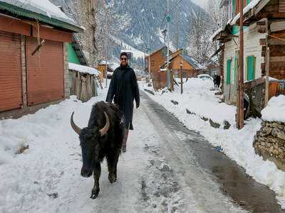
New Delhi [India], January 21 (ANI): Under the influence of Western Disturbance, wet spell is likelyover Western Himalayan region during the next seven days with possibility of isolated heavy rainfall or snowfall over Kashmir valley on January 22 and 23 and Himachal Pradesh and Uttarakhand on January 23, IMD said on Tuesday.
It said that isolated to scattered rainfall is likely over adjoining plains of northwest India during January 22 to 24.
Dense fog conditions are very likely at isolated places over Punjab, Haryana, Chandigarh, during the next two-three days.
It said very dense fog conditions prevailed in some parts of Haryana and West Rajasthan and dense fog conditions prevailed in isolated pockets of Punjab, West Uttar Pradesh, East Rajasthan and Meghalaya on Tuesday morning.
Cold wave to severe cold wave conditions prevailed in some parts of Himachal Pradesh and cold wave conditions in isolated pockets over Punjab. Ground frost conditions were recorded in isolated pockets of Uttarakhand.
Minimum temperatures were 1-4°C at few places over Himachal Pradesh and Uttarakhand; 5°-9°C at many places over remaining parts of Punjab, Haryana, Chandigarh and Delhi and at few places over Uttar Pradesh and Madhya Pradesh during past 24 hours till 8.30 am on Tuesday.
Minimum Temperatures were above normal by (2°C to 5°C) over Central India and adjoining western India, Haryana, East Uttar Pradesh, Bihar, Assam & Meghalaya and below normal (-2°C to -4°C) at isolated places over Jharkhand, Chhattisgarh, Odisha, Telangana, Rayalaseema, Tamil Nadu and near normal over rest parts of the country.
The lowest minimum temperature of 2.8°C was observed at Amritsar.
The weather office said that an upper air cyclonic circulation lies over northwest Uttar Pradesh and neighbourhood in lower tropospheric levels.
It said that an intense Western disturbance is likely to affect Northwest India from the night of January 21.
An upper air cyclonic circulation lies over southeast Bay of Bengal & neighbourhood in middle tropospheric level and an upper air cyclonic circulation lies over northeast Assam & neighbourhood in lower tropospheric level.
The weather office also said that subtropical westerly Jet Stream with core winds of the order of 130 knots at 12.6 km above mean sea level prevails over North India. (ANI)
-
Republic Day 2026: Visit These Iconic Mumbai Landmarks That Will Bring Out The Patriot In You

-
Army leads joint counter-drone drill in Assam ahead of Republic Day
-
Maharashtra's sustainable housing projects bags silver at World Habitat Awards

-
Myanmar currency, drugs seized in two NE states; 7 held

-
Vadivukkarasi's horror thriller 'Granny' censored with U/A certificate