The latest weather maps show snow blizzards hitting the UK again early next month bringing snow and cold temperatures as far south as London.
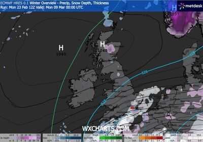
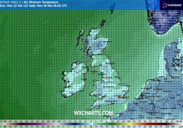
Weather maps from WXCharts.com show temperatures below the 0 across the UK with most areas between -2C and -4C, or even -7C in the north of Scotland on Monday, March 9. Snow and rain are also expected the following day (March 10) across the south west and south east of England.
On March 9, snow is likely to hit the south east of the country including London and other areas in Southampton, Ipswich, and Norwich at up to 10mm per hour, WXCharts maps show.
The maps also suggest that parts of Scotland could see the mercury plummet to a bone-chilling -13C. While most cities in the north of England will experience the bitterly cold conditions, parts of England including Manchester, Leeds, Liverpool, Newcastle might see temperatures dropping to -3C and -5C
A long-range weather forecast from the Met Office said during those days "changeable conditions are expected, with Atlantic frontal systems spreading across the UK".
This week, however, the UK's seemingly endless downpours are about to take a bizarre twist - with forecasters warning crimson-coloured 'blood rain' falling across parts of the country this week.
The country now faces an additional weather phenomenon as a colossal red dust cloud originating from the Sahara Desert reaches the nation.
*** Ensure our latest news headlines always appear at the top of your Google Search by making us a Preferred Source. Click here to activate or add us as Preferred Source in your Google search settings. ***
The blood rain forecast arrives on the heels of Met Office warnings that waterlogged conditions will likely continue until the middle of March.
Sarah Davies, Head of Energy and Environment at the Met Office said: "Wet weather has persisted for many areas over the past few weeks, with repeated Atlantic low pressure systems leaving ground conditions particularly saturated across southern parts of the UK.
"While it is likely to remain changeable over the next few weeks, with further wet weather at times, the focus for the wettest conditions is expected to shift to western hills, where we would normally expect it at this time of year.
"However, given some areas elsewhere remain sensitive following recent rain, any further spells of rain as we head into early spring has a higher chance of causing some impacts than normal for this type of setup."
-
King Harald of Norway rushed to hospital as urgent health update issued

-
Tragic Loss: Katherine Short, Daughter of Martin Short, Passes Away

-
Turkey plane crash LIVE: Balkesir horror as F-16 jet smashes in huge 'explosion'

-
Handy 'old trick' that costs 3p gets rid of stubborn mug stains in 10 minutes

-
"This decision might have implication on upcoming election...": AIADMK's Gautami Tadimalla on Sasikala launching new party flag