
Despite spring finally being upon us, UK weather maps have turned a striking shade of purple as fresh snow sweeps southwards, with wintry flurries forecast to reach as far south as Yorkshire and Cumbria by the end of the week. New WXCharts maps from the ECMWF model show a band of heavy precipitation pushing south across northern Britain during the early hours of Friday (March 6), with lingering cold air allowing snow to fall even in lower levels.
The latest maps also indicate minimum temperatures widely between -1C and 3C across northern England and southern Scotland, cold enough for snow and sleet to settle, especially over higher ground. Parts of the Highlands are forecast to plunge several degrees below freezing, as low as -5C in inland areas and to -2C near Aberdeen and Dundee. A chart predicting 'Instantaneous precipitation rate, Cloud, Temperature and Pressure' for 3am on Friday shows snow showers feeding into eastern Scotland before descending south into Northumberland, Cumbria and Yorkshire.
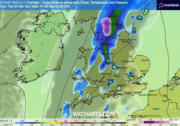
The heaviest bursts are highlighted in purple, signalling higher snowfall rates, with over 2mm/hr expected in areas near the North Pennines and the Yorkshire Dales National Park.
Cities including Newcastle, Leeds and Manchester sit close to the rain-snow boundary in the early hours, with the potential for disruptive bursts as the system moves southwards.
Further south, outbreaks of heavy rain are shown across the Midlands and parts of southern England, with brighter colours of blue, green, yellow and even red on the rainfall chart indicating downpours capable of producing tricky driving conditions for the morning commute. A particularly heavy downpour is predicted just northeast of London, where over 4mm/hr of rain could fall.
*** Ensure our latest news headlines always appear at the top of your Google Search by making us a Preferred Source. Click here to activate or add us as Preferred Source in your Google search settings. ***
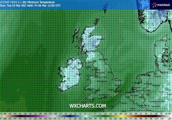
Higher ground in the north is most likely to see snow settling, but even some lower areas could briefly turn white where heavier showers fall and temperatures drop below freezing overnight. By daylight hours on Friday, snow showers may still be affecting parts of northern England, while central and southern areas face a mix of rain and windy conditions.
The Met Office's forecast for the Yorkshire Dales on March 6 reads: "Mainly dry with sunny or clear spells, early frost possible. Moderate west or northwest winds. Freezing level could be well down at first, but soon rising above the summits during the day."
Meanwhile, the outlook for the period of Thursday (March 5) to Saturday (March 7) for the wider North West England region for the same day reads: "Largely dry and bright on Thursday, but rain arriving later. High pressure builds back in from Friday bringing plenty of dry and bright weather, but temperatures returning to nearer average."
-
Martin Keown notices three things Arsenal need to tweak as Mikel Arteta avoids Chelsea problem

-
2026 SSC MTS and Havaldar Answer Key Released

-
Iconic Tenerife hotspot launches major tourist crackdown - 290k visitors a year

-
Winning EuroMillions numbers LIVE: Full lottery results with Thunderball on March 3

-
TV host speechless as William's two-word bombshell leaves Beatrice and Eugenie blindsided