A newly circulated simulation map outlining the devastating consequences of a nuclear conflict in the United States also identifies areas that may face comparatively lower levels of destruction. While the projections rely on modeled phases rather than real-time occurrences, they provide insight into how geography and target distribution could shape the magnitude of destruction.
According to NUKEMAP, Western Texas, much of Nevada, alongside regions of Michigan and Wisconsin, would be "notably in the clear," reports Mira Safety, which analyzed the results. However, analysts warned, "With that said, the latter two would likely become uninhabitable in the coming nuclear winter."
Growing Fears Amid Global Conflict
Concerns regarding the nuclear escalation have amplified in recent years. Russia’s continuing invasion of Ukraine has increased alarms among defense experts who caution that tactical nuclear weapons could possibly be used. Anxiety intensified again across the United States after Iran’s Supreme Leader Ayatollah Ali Khamenei was reportedly killed during a “massive” and ongoing military operation aiming at Iran's leadership and armed forces, executed jointly by the U.S. and Israel.Major Cities Seen as Likely Targets
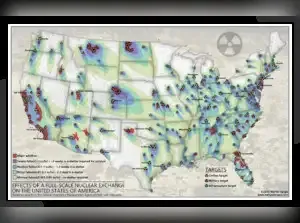
Densely populated metropolitan areas are widely considered prime targets in any nuclear clash. As the most highly populated urban region in the country, New York City would represent a main objective in a conflict phase. With millions of residents in a relatively small geographic place, the consequences of a nuclear detonation there would be devastating.A risk evaluation map compiled using details from the Federal Emergency Management Agency (FEMA) briefs probable civilian hubs, military facilities, and infrastructure sites that could be aimed. On this map, areas shaded in blue, yellow, and red suggest higher-risk zones, while the limited regions without those markings are regarded as comparatively safer.
Fallout Risks Extend Beyond Ground Zero
Even communities situated far from direct impact zones would not be free from danger. The American Red Cross recommends that people outside immediate strike areas would likely be required to stay indoors for at least 24 hours unless officials offer alternative guidance. In more severe situations, residents could be advised to shelter in place for up to one month to minimize exposure to radioactive fallout.Understanding the Limits of NUKEMAP
The simulation platform NUKEMAP was created by Professor Alex Wellerstein, a historian specializing in science and nuclear technology. The tool highlights that it is made for public education rather than emergency response planning.NUKEMAP explains itself as:
"intended as an educational resource. It should not be used for emergency planning or emergency response purposes where lives and health might be on the line. It is not a perfect simulation. The NUKEMAP is aimed at helping people visualize nuclear weapons on terms they can make sense of — helping them to get a sense of the scale of the bombs. By allowing people to use arbitrarily picked geographical locations, I hope that people will come to understand what a nuclear weapon would do to places they are familiar with, and how the different sizes of nuclear weapons change the results."
Source: Daily Express US
FAQs:
Q1. Would any part of the U.S. be completely safe during a nuclear war?No location would be completely protected from the consequences. Fallout, supply chain interruption, and economic collapse would affect nearly every region.
Q2. Why are major cities considered primary targets?
Large cities concentrate population, infrastructure, and economic power. This makes them strategic objectives in a military conflict.