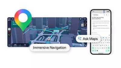
The changes include a new feature called Ask Maps and a redesigned navigation system called Immersive Navigation. Google said these updates represent its biggest navigation upgrade in more than a decade and aim to make searching for places and driving directions easier for everyday users.
Ask Maps allows users to ask questions about places
Google's latest addition, Ask Maps, lets users inquire about places within the Maps app itself. Rather than relying on basic keywords, users can now ask complete questions. For example, users may ask where they can charge their phone nearby or find a public tennis court that has lights at night.
The feature analyzes information from Google Maps’ database of more than 300 million places. It also uses reviews from a community of more than 500 million contributors.
Ask Maps provides answers along with a map view that shows suggested locations. The feature also gives additional details such as directions, estimated travel times and recommendations shared by other users.
Google said the results are personalized based on the user’s past searches and saved locations in Maps. For example, if a user frequently searches for vegan restaurants, the system may suggest similar options when recommending meeting places.
Users can also take action from the results by booking reservations, saving locations to lists or sharing places with friends. The feature is rolling out to users in the United States and India on Android and iOS devices, with a desktop version planned later.
Immersive Navigation comes to Google Maps
Google is also updating the navigation system in Maps with a feature called Immersive Navigation. The update changes how maps appear while driving. The navigation view will now show a three-dimensional display of buildings, roads and surrounding areas.
Google Maps will also highlight important road details such as lanes, crosswalks, traffic lights and stop signs. The company said this information is generated by analyzing Street View images and aerial photos using Gemini AI models.
The system will also provide a wider view of the route ahead to help drivers prepare for turns and lane changes. The map will zoom out automatically when needed and display transparent buildings to improve visibility.
Voice instructions have also been updated to sound more natural. Instead of short commands, the system may provide guidance such as telling the driver to pass one exit and take the next one.
Google Maps to show route options and real-time alerts
With the update, Google Maps will also explain the differences between alternate routes. For example, it may show a longer route with less traffic or a shorter route that includes toll roads. The system will also alert drivers about road closures, construction work or accidents along their route.
These alerts are partly based on reports from drivers using the platform. According to Google, users submit more than 10 million traffic reports every day.
Google Maps will also provide additional information as users approach their destination. Drivers will be able to preview the location using Street View images before starting their trip. The app may also suggest nearby parking spots.
As the driver gets closer to the destination, the map will highlight the building entrance and indicate the correct side of the street.
Google said Immersive Navigation is starting to roll out in the United States and will expand to more regions in the coming months. The feature will be available on Android, iOS, CarPlay, Android Auto and vehicles that support Google built-in services.
-
Stay worry-free regarding LPG; a large consignment of gas is arriving in India, with supplies coming from these countries..

-
OPS-NPS: Over 5 million employees in the Central Government; OPS-NPS data revealed...

-
New Rule Implemented in NPS: Separate Categories for Government and Non-Government Institutions..
-
With crude oil prices soaring due to the war, you too can make money from this surge! Here is how..

-
AC Tips: Get Your AC Serviced Now; Delaying It Will Only Increase Your Troubles..