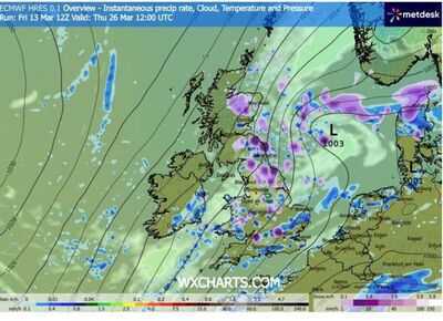
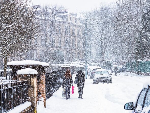
New weather maps show the UK could face 48 hours of snow and blizzard conditions, with large parts of England set to be hit over several days. Forecast charts from WXCharts indicate snow spreading across the country between March 26 and March 28.
The first map is valid at 12noon on Thursday, March 26, and shows snow pushing into northern England. Purple shading on the chart suggests heavy snowfall across Northumberland, County Durham, Cumbria and North Yorkshire, with wintry showers also affecting parts of Lancashire and West Yorkshire.
Snow is also shown moving south into parts of the Midlands, including Derbyshire, Nottinghamshire and Staffordshire.
Further bursts of snow appear across Lincolnshire and Norfolk, while colder air spreads across eastern England.
By Saturday, March 28 at 12noon, a second chart suggests snow could still be falling across parts of the country. This means the wintry conditions shown on the maps span for at least 48 hours.
The later chart shows snow stretching further south and east across England. Counties including Essex, Kent, East Sussex, West Sussex and Surrey appear under snow showers on the map.
Further wintry bursts are also shown across Hampshire and Dorset, while snow showers remain possible across parts of the Midlands and northern England.
In total, around 23 English counties appear to see snow at some stage during the period shown on the charts.
However, longer-range forecasts suggest the wider weather pattern could soon turn more settled.
According to the Met Office long-range forecast for March 18 to March 27, much of the UK is expected to see more settled conditions developing after an unsettled start.
The forecaster said: "Signs are that much of the UK will see a period of more settled weather for part of this period at least."
It added that early wet and windy weather in the far northwest should be short-lived before drier conditions spread.
The Met Office said: "It is likely to quickly turn more settled everywhere, with most places predominantly dry."
Temperatures are expected to fluctuate between milder and colder than average, meaning some places could still see overnight frost and fog.
The outlook added that by day there should be spells of pleasant spring sunshine, although eastern coastal areas may feel cooler in a brisk easterly wind.
Looking further ahead into early April, the Met Office says blocked weather patterns could develop.
This could increase the chance of colder spells and frost, although overall temperatures are expected to stay close to average for the time of year.
-
'No More Chota Bhai': BJP Will Contest 2027 Punjab Polls Alone, Says Amit Shah

-
Dhurandhar 2 Music Launch in Mumbai: Date, Venue, How To Register For Free, And More

-
‘Countdown Has Begun’: PM Modi Launches Sharp Attack On TMC At Kolkata Rally

-
East Bengal Seek Crucial Home Victory Against Winless Kerala Blasters; Bengaluru FC Host Unbeaten Mohun Bagan SG

-
Delhi: Student Jumps Onto Metro Track In Dwarka Sector-14, Injured