Parts of the UK appear to be in for a colder and wetter week, despite the façade of spring appearing just a few days ago. The UK recorded its warmest day of the year so far last week, reaching 20.9C in Wales on Wednesday, March 18, the Met Office said. However, temperatures are expected to fall this week, with the risk of frost and ice for some, latest weather maps suggest.
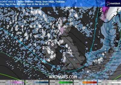
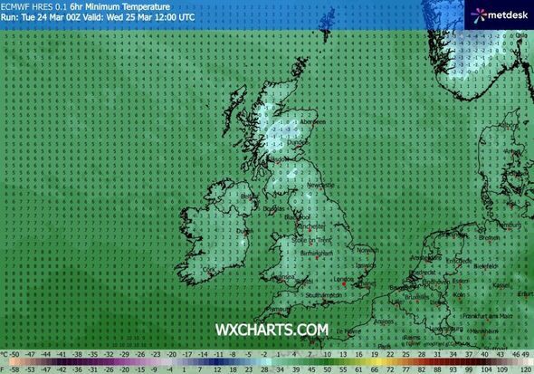
New maps from WXCharts generated on March 24 using Met Desk data suggest snow may hit several cities in the UK - including Manchester, Newcastle and areas near Swansea and London - as soon as tomorrow, March 25. The maps also show snow could fall in several areas of western Scotland. Weather maps also suggest temperatures tomorrow could be as low as -2C.
This comes as, in a separate forecast, the Met Office said colder weather than what has been witnessed in recent days should be expected tomorrow in some areas of Britain. "After a spell of mild and brighter weather, the UK will turn increasingly unsettled in the coming days. A series of weather fronts will bring periods of rain, strong winds and much colder air by midweek. Wednesday could be quite a shock to the system," Met Office Deputy Chief Forecaster Steven Keates said.
Keates said wintry showers are likely, especially over higher ground in the north, and a widespread frost, with icy patches for some, is possible on Wednesday night.
In its weather forecast for Wednesday, the Met Office said: "Sunny spells and blustery wintry showers. The showers most frequent across the north and northwest where they will be heavy with hail and thunder. Feeling cold with brisk winds."
The Met Office previously explained forecasting snow in the UK is more complex than in continental Europe due to rapidly-changing conditions. Its website read: "Small variations in temperature or wind direction can mean the difference between rain, sleet or snow. Meteorologists use high-resolution models to predict precipitation type, but these models can struggle with marginal situations where temperatures hover around freezing.
"Forecasters also consider factors such as precipitation intensity. Heavy bursts of precipitation can cool the air near the surface, increasing the chance of snow. Conversely, lighter precipitation may melt before reaching the ground. This fine balance makes snow forecasting one of the most uncertain aspects of UK weather prediction."
-
Rajasthan Royals Sale: IPL’s first champion Rajasthan Royals sold, know who bought it for Rs 1.53 lakh crore?

-
Travelling to India? e-Arrival Card Becomes Mandatory From April 2026

-
Puducherry Elections 2026: The X-Factors That Will Decide the Winner | Election 2026

-
Is there a money line on your palm? How to identify it? Know 5 facts – News Himachali News Himachali

-
Iran war has had a bad impact on durable goods, stocks of these companies have fallen by 21 percent.
