
Shocking new weather data suggests that parts of Britain could be braced for snow despite enduring the seventh warmest April on record. Forecasts predict that large parts of the country could see temperatures in excess of 17C this week, but new weather data suggests that this could be followed by unseasonal wintery conditions.
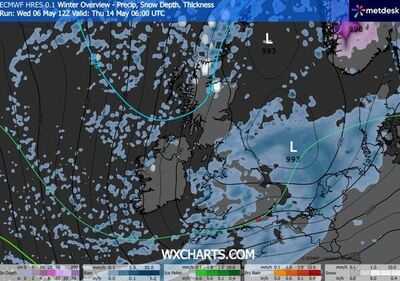
New weather data provided by WXcharts.com shows several parts of the UK turning purple, indicating snow, from Thursday 14 May, lasting approximately 72 hours. The maps show the scattered incidents of wintery weather extending southwards through Friday 15 May, into Saturday, hitting areas as far south as Devon, Dorset and Surrey. Amid isolated showers, the snowy weather could stretch as far as the South Coast, in an unseasonal display of wintery conditions.
According to WXChart.com's data, snow will hit land in the north of Scotland, before sweeping down through the UK throughout Friday.
UK airline collapses into liquidation - all flights cancelled
Urgent recall issued for five products sold at Aldi
Snow will be heaviest in the Scottish Highlands, but is also predicted to fall over areas in the North West, Bristol, Portsmouth and Cardiff.
It will be accompanied by rain across much of England and Wales, with conditions expected to be most severe in the east of the country.
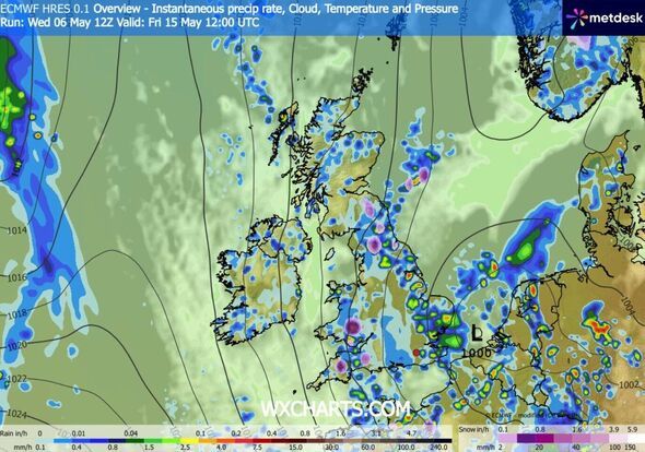
According to WXCharts.com, an inch of rain could fall each hour on Britain's east coast, drenching large parts of Kent, Suffolk and Norfolk and stretching as far north as Hull.
The predictions have not been predicted by the Met Office, who instead warn of "unsettled conditions" through the period.
A Met Office forecast for 11 May to 20 May said: "Changeable and at times rather unsettled conditions look to dominate through the middle part of May, with low pressure often close by.
"This means periods of rain or showers, some of which could be heavy, for many places, though some drier interludes are also expected.
"For the most part, temperatures are likely to be close to or perhaps a little below normal, though depending on the position of low pressure relative to the UK, there is the chance of brief warmer more humid interludes extending north from the near continent.
"With this would be the chance of some thunderstorms, these most likely affecting parts of England and Wales."
-
KTR booked over ‘derogatory remarks’ against Rahul Gandhi

-
Questioning religious practices will break religion, civilisation: SC

-
Andhra bags Royal Enfield’s Rs 2,200 crore first expansion project outside Tamil Nadu

-
Alcoholic beverage industry seeks price hike amid rising costs from West Asia crisis

-
Samantha’s ‘Maa Inti Bangaaram’ release date changed due to IPL