Initially, it might appear that the Konya Basin in the middle of Turkey is stable. The area is wide, arid, and fairly flat, being influenced by the presence of farmland, desert landscapes, and regions prone to sinkholes. However, recent satellite observations and geophysical analysis revealed that there are sections of the basin that experience slow subsidence in an unexpectedly dense cluster.
According to a 2024 Nature Communications paper, this subsidence is highest in the basin's central region, allowing scientists to identify a particular region characterized by rapid subsidence, dubbed a "bullseye." This is a crucial point since the process of deformation does not occur uniformly throughout all of central Turkey but rather is highly concentrated in the very center of the basin. Some areas experienced sinking of up to tens of millimeters annually. While it does not seem significant, subsidence of this nature is bound to have severe negative impacts on infrastructure.
This discovery generated interest due to the fact that the sinking cannot be easily explained by other theories, like sediment settling or large-scale bending of the continental crust. The study conducted by researchers from Nature Communications concludes that the process is rather linked to a deeper tectonic process that occurs at great depths.
This phenomenon is believed to involve the detachment and subduction of the bottom portion of the lithosphere found under central Anatolia in a process known as mantle lithospheric drip. Simply put, there seems to be a dense portion of Earth’s crust and mantle that is breaking off and sinking under its own weight.
Geologists attribute this peculiar process to the fact that the deeper unroofing of the lithosphere often triggers a differential response on its surface, causing uplifts in some areas while triggering collapses into localized basins in other areas. In this sense, the Konya Basin operates similarly to a basin developing inside an uplifting plateau.
The exploitation of groundwater can further exacerbate the situation in the upper layer. In addition, the Konya Basin is highly dependent on underground water reservoirs for agricultural and domestic purposes. The U.S. Geological Survey states that excessive groundwater abstraction can cause the sediment compression process and enhance the process of land subsidence in areas that are already prone to this phenomenon.
Hence, scientists are convinced that there could be two distinct forces acting on the area simultaneously, namely, the deeper tectonic mechanism and the superficial surface mechanism caused by water usage. This scenario appears particularly disturbing since the territory of central Turkey is already characterized by spectacular sinkhole formation due to the impact of karst terrain and groundwater depletion.
Denser materials within the lower parts of the crust and upper mantle slowly peel off and sink, changing the force balance in the land masses above. It contributes to the changes in plateaus, basins, and continental structure. This case, at the same time, proves that modern science relies increasingly on the combination of various approaches. The movement of the ground can be registered from space using InSAR and GNSS, while seismic and gravity surveys look deeper inside the Earth. Geological modeling finally unites all the evidence in a single theory.
But for those who live in the area, the problem is much more than just an academic study of geology. The impact of sinkholes, cracked ground, and sinking lands can have a direct effect on agriculture, roads, buildings, and underground waterways. The process of motion becomes an everyday reality before any catastrophic event takes place.
The implications are even broader than the implications of Turkey. The example of the Konya Basin teaches geologists that the land masses known as continents are not static and unmoving. They can become thinner, peel apart, rise up, fall down, and change their configuration constantly.
According to a 2024 Nature Communications paper, this subsidence is highest in the basin's central region, allowing scientists to identify a particular region characterized by rapid subsidence, dubbed a "bullseye." This is a crucial point since the process of deformation does not occur uniformly throughout all of central Turkey but rather is highly concentrated in the very center of the basin. Some areas experienced sinking of up to tens of millimeters annually. While it does not seem significant, subsidence of this nature is bound to have severe negative impacts on infrastructure.
This discovery generated interest due to the fact that the sinking cannot be easily explained by other theories, like sediment settling or large-scale bending of the continental crust. The study conducted by researchers from Nature Communications concludes that the process is rather linked to a deeper tectonic process that occurs at great depths.
This phenomenon is believed to involve the detachment and subduction of the bottom portion of the lithosphere found under central Anatolia in a process known as mantle lithospheric drip. Simply put, there seems to be a dense portion of Earth’s crust and mantle that is breaking off and sinking under its own weight.
Scientists believe the crust is being pulled downward from deep below
It may seem like an outrageous claim, but according to geologists, the phenomenon correlates with numerous types of data obtained from various areas of the region. According to the findings, both seismic reflection, gravity, topography, and space-based measurements of land deformation indicate ongoing lithospheric unroofing beneath Central Anatolia. What makes the phenomenon especially interesting is the fact that the larger Central Anatolian Plateau continues to uplift despite the sinking Konya Basin, meaning that two contradictory processes of crustal movement take place at the same time in the area.Geologists attribute this peculiar process to the fact that the deeper unroofing of the lithosphere often triggers a differential response on its surface, causing uplifts in some areas while triggering collapses into localized basins in other areas. In this sense, the Konya Basin operates similarly to a basin developing inside an uplifting plateau.
The exploitation of groundwater can further exacerbate the situation in the upper layer. In addition, the Konya Basin is highly dependent on underground water reservoirs for agricultural and domestic purposes. The U.S. Geological Survey states that excessive groundwater abstraction can cause the sediment compression process and enhance the process of land subsidence in areas that are already prone to this phenomenon.
Hence, scientists are convinced that there could be two distinct forces acting on the area simultaneously, namely, the deeper tectonic mechanism and the superficial surface mechanism caused by water usage. This scenario appears particularly disturbing since the territory of central Turkey is already characterized by spectacular sinkhole formation due to the impact of karst terrain and groundwater depletion.
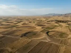
AI Depiction of Konya Basin, Turkey | Image Credit: Gemini
The Konya Basin is becoming a rare window into how continents change
It is precisely because of these features that the Konya Basin has scientific significance. While most people tend to perceive movements in the crust via volcanic and earthquake activity, it is important to note that even without this, Earth's crust can slowly move for years, while its deeper sections undergo some sort of silent reconstruction. As mentioned by experts cited in the article in Nature Communications, the Konya Basin provides an excellent example of lithospheric “dripping” in modern times.Denser materials within the lower parts of the crust and upper mantle slowly peel off and sink, changing the force balance in the land masses above. It contributes to the changes in plateaus, basins, and continental structure. This case, at the same time, proves that modern science relies increasingly on the combination of various approaches. The movement of the ground can be registered from space using InSAR and GNSS, while seismic and gravity surveys look deeper inside the Earth. Geological modeling finally unites all the evidence in a single theory.
But for those who live in the area, the problem is much more than just an academic study of geology. The impact of sinkholes, cracked ground, and sinking lands can have a direct effect on agriculture, roads, buildings, and underground waterways. The process of motion becomes an everyday reality before any catastrophic event takes place.
The implications are even broader than the implications of Turkey. The example of the Konya Basin teaches geologists that the land masses known as continents are not static and unmoving. They can become thinner, peel apart, rise up, fall down, and change their configuration constantly.