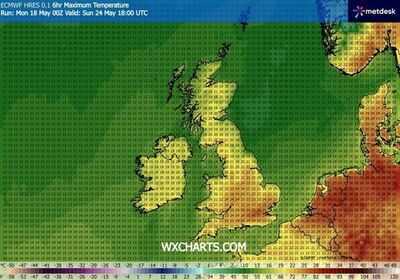
This Bank Holiday weekend looks set to be a scorcher with the mercury soaring up to 25C or more for some. Weather maps generated by WX Charts on Monday (May 18) show the hottest counties will be predominantly in the south of the country.
One map shows that on Bank Holiday Monday (May 25) temperatures range from 22C to 25C by 6pm. WX Charts' map shows 22-23C in Cornwall, 21-22C in Devon as well as 22C-23C in Somerset, Dorset, Wiltshire and Gloucestershire. Hampshire looks set for the mercury to hit 23-24C at the same time, with Surrey seeing 24-25C, Greater London 25C, Sussex 21-23C and up to 24C in parts of Essex.
Oxfordshire, Hertfordshire, Buckinghamshire, Herefordshire and Shropshire look set to see top temperatures ranging from 21-23C, according to WX Charts.
In Wales, top temperatures range from 20C to 22C in Anglesey, Conwy, Gwynned, Powys, Flintshire, Denbighshire, Pembrokeshire, Carmarthenshire, Glamorgan, Monmoutshire, Wrexham, Swansea, Neath Port Talbot, Bridgend, Rhondda Cynon Taff, Merthyr Tydfil, Blaenau Gwent, Caerphilly, Torfaen, Newport and Cardiff.
Counties in Northern Ireland look set to see the mercury reach 21-22C at 6pm on Bank Holiday Monday, while parts of Scotland may see the same.
It is important to remember that the above temperatures are based on a single model and other charts may vary as the weekend gets closer.
The Met Office forecasts Friday (May 22) to be the warmest day of the year so far, but before then showers are expected for some, with heavy bursts affecting north western parts of the country.
It expects a mild start to Tuesday, but also a damp day with rain heading in to the UK from the Atlantic.
Wednesday brings more sunshine as a high moves towards the UK, pushing a low eastwards. It will feel cool across the north of Britain because of the wind, but elsewhere will feel warmer.
Drier, warmer weather moves into the south on Thursday, but it remains wet in the north. Thursday will see temperatures well into the 20Cs, according to the Met Office, as a warming trend takes hold.
Met Office Deputy Chief Forecaster Tony Wisson said: "The weather later this week will feel like a marked contrast from recent days, with warm, fine and settled weather for many.
"While the warmth will persist through the Bank Holiday weekend, conditions will turn more unsettled later Friday and into Saturday, with a mix of cloud, showers and longer spells of rain. There is also the chance of thundery rain in places."
He added that despite this, temperatures should remain warm or very warm through Saturday and into Sunday, with highs around 26C in the south across the weekend and into next week.
Heavy, thundery showers could be seen on the south coast later in the day on Friday, but it will be warm, with the possibility of 28C in London.
High pressure grows more dominant from Sunday into Bank Holiday Monday, bringing drier, warmer weather, according to the Met Office.
-
3 Things The Most Intelligent Person In The Room Is Almost Always Doing

-
3 Zodiac Signs Feel Immense Happiness Starting On May 19, 2026

-
Singapore’s beloved Cantonese restaurant to close after 100 years

-
Will all be well in your life on Tuesday? read horoscope

-
Atonemo Streamplayer Launches in India to Modernize Old Speakers