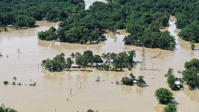
Aerial image of Upper Assam inundated under floodwaters hinting at the large scale devastation (Photo: @himantabiswa/X)
Guwahati, July 23: The Indian Meteorological Department (IMD) has dismissed recent reports suggesting cloudbursts in Assam and Nagaland, which were believed to have caused the severe flooding in Upper Assam. Despite this, the flooding in eastern Assam has highlighted the region's inadequate climate-resilient infrastructure, including weak embankments and roads, alongside the ongoing loss of wetlands that are vital for flood management.
An official from the IMD in Nagaland indicated that the Aboi ARG station in Mon district recorded 137 mm of rain on July 19, marking the highest rainfall in the state this season. However, this amount does not meet the criteria for a cloudburst, which requires at least 100 mm of rain within an hour. On other days, rainfall in Nagaland remained below 100 mm.
The IMD Centre in Guwahati also confirmed that no cloudburst incidents have been reported in Assam. On July 19, Sonari experienced 190 mm of rainfall, but instances of very heavy rain were limited in other regions.
“Rainfall figures like these are not unusual for the Northeast. This is not the first occurrence. Similar rainfall events have been documented previously. Therefore, rainfall alone cannot account for the flooding, especially in areas experiencing such deluge for the first time,” stated an IMD scientist.
Experts consulted pointed to various factors contributing to the extensive damage, particularly in the districts of Jorhat, Sivasagar, and Charaideo. A study highlighted that “flood damage in Assam cannot be solely attributed to meteorological factors; it arises from the interplay of hydrological processes, socio-economic conditions, and the resilience of ecological and infrastructural systems.”
Issues with embankments: Prior to the recent heavy rainfall, 18 breaches in embankments were reported between April 29 and July 6, with an additional 25 embankments suffering damage from rising river waters. Since July 17, Jorhat district alone has reported six breaches, raising concerns about their maintenance and structural soundness.
Previous analyses have shown that while embankments can mitigate flood intensity, their effectiveness is often compromised by inadequate maintenance, erosion, and design flaws. A review of embankment breach data revealed a strong correlation between severe flood damage and failures of embankments in the most affected districts.
Concerns over road construction: The road infrastructure, particularly newly built roads, has also faced criticism. Experts note that many roads have been elevated, several bridges have been replaced with culverts, and both the quantity and size of culverts have been diminished. “These modifications could hinder the natural drainage of floodwaters or change their flow patterns. However, a comprehensive scientific study is necessary to determine the full extent of their impact,” remarked a professor from Gauhati University. Between July 17 and July 20, the ASDMA reported breaches in 58 roads across the flood-affected areas.
Wetland and forest degradation: Another significant contributor to the flooding is the degradation of wetlands. The hydrological link established by flooding between wetlands and rivers is crucial for the river-floodplain ecosystem.
For example, the Panidihing Bird Sanctuary in Sivasagar district is a wetland where the Brahmaputra, Desang, and Demow rivers have created a unique hydrological system by connecting streams and wetlands. In 2021, only 15 wetlands covered an area of 0.82 sq. km out of a total of 33.9 sq. km. The study indicated that the area of flooding within the sanctuary was greater in 2001 at 18.9 sq. km compared to 2021, when water pixels covered 5.9 sq. km on rainy days.
-
FBI Arrests Indian National Harmanveer Singh In US Over Alleged Drug Trafficking Links

-
Bangladesh President Shahabuddin Likely To Resign As Political Tension Deepens In Country: Reports

-
PM Modi announces paper leak bill, Rahul calls video ‘pathetic’
-
Sonam Wangchuk ends 26-day fast, but keeps conditions secret

-
Wangchuk ends hunger strike after govt assures him of meeting his demands