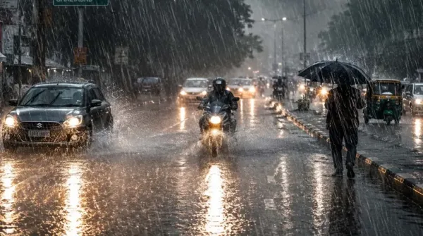
The movement of monsoon across the country is once again very dangerous and rapidly changing. India Meteorological Department (IMD) has issued a serious warning of torrential rain and lightning for many states of the country. If you are planning to travel somewhere in the coming days, then it is very important for you to know this latest weather update. Let us know how the weather of your city will be in the coming days.
Orange alert in these 4 states, special advisory for farmers
Today there is every possibility of heavy rain in Rajasthan, West Bengal, Central Maharashtra and Odisha. According to meteorologists, due to the strengthening of the low pressure area, the rainfall in these areas will become very intense. Apart from this, there will be light clouds in Delhi and surrounding areas and people can get some relief from the humid heat due to light drizzle.
Today, the weather is going to be harshest in Eastern Rajasthan, plains of West Bengal, Central Maharashtra and Odisha, due to which the Meteorological Department has issued warning for these areas. orange alert Has been released. There will be strong winds along with the rain and there is a big danger of lightning along with thunder. In view of this dangerous weather, farmers have been advised to take special precautions. Filling the fields with water can cause damage to crops, so make proper arrangements for drainage. During storms, tie your cattle to a safe place and do not leave valuable agricultural goods in the open.
New system ready in Bay of Bengal, game will change on 15-16 August
This cycle of weather is not going to stop here. A new low pressure area is going to take shape in the north-western Bay of Bengal around August 13. Along with this, another seasonal system is already active in the central-eastern parts of the country. Due to the meeting of these two, the effect of monsoon will become more profound.
On August 13 and 14, its worst impact will be seen in Odisha, Jharkhand and Chhattisgarh, where heavy to very heavy rainfall can be recorded in many districts. After this, on Independence Day i.e. 15th August, this rain will move forward and reach Eastern Uttar Pradesh and Eastern Madhya Pradesh.
Temperature of major cities (13 August)
| City | maximum temperature | minimum temperature |
| Delhi | 36°C | 29°C |
| Mumbai | 29°C | 27°C |
| Chennai | 36°C | 29°C |
| Kolkata | 30°C | 27°C |
| Lucknow | 35°C | 28°C |
| Patna | 34°C | 28°C |
| Ranchi | 28°C | 23°C |
| Bhopal | 28°C | 24°C |
| Jaipur | 33°C | 26°C |
| Shimla | 27°C | 21°C |
| Nainital | 27°C | 22°C |
Monsoon direction will reverse from August 16, danger will increase on mountains
Right after Independence Day i.e. after 15th August, the entire cycle of weather will once again take a U-turn. From August 16, the main trough line of monsoon will start moving northwards. Due to this, the main center of rain will be the foothill areas of Bihar, Nepal and eastern Uttar Pradesh. When the monsoon trough moves towards the mountains in the north, the rainfall in the plains and southern areas reduces significantly, which is also called a break in the monsoon in meteorological language. It is estimated that this weather trend will continue till approximately 20th August.
When the monsoon trough will move towards the north, the rainfall in the areas located in the foothills of the Himalayas will become very severe. Between August 16 and 20, torrential rains may become a disaster in eastern Uttar Pradesh, Bihar, Jharkhand, Sikkim and northern parts of West Bengal. Due to continuous rain in the mountains, the water level of the rivers will rise rapidly and a flood-like situation may arise in the low-lying areas. There will also be a strong danger of landslides on the hilly roads, so keep a close eye on the warnings of the local administration.
Speed will slow down in South and Central India
Increase in rainfall in North India and mountains will have a direct impact on the rest of the country. The pace of monsoon will slow down significantly in western, central and south India after August 16. In Rajasthan, Gujarat, western parts of Madhya Pradesh and most of the states of South India, the weather will be limited to dry or light showers. At present, no new major system is seen forming in the Bay of Bengal till August 21, although if the direction of the winds changes, a change in the forecast is also possible.
-
HYC founder attempts suicide in Hyderabad over police harassment

-
NALSAR students won’t withdraw demand on CJI, but won’t boycott
-
LIVE: PM Modi addresses nation on 80th Independence Day
-
Two interstate thieves from Irani gang arrested in Karnataka

-
Hyderabad assets of ex-AP minister attached in liquor case