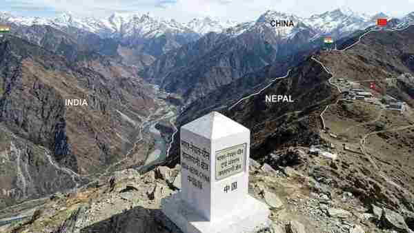
There has been a historic and shocking turn in the geopolitics of South Asia and the India-Nepal border dispute which has intensified diplomatic activity from Kathmandu to New Delhi. The Government of Nepal has officially admitted that the original signed documents of the historic 'Sugauli Treaty' signed between the British East India Company and Nepal in the year 1816 do not exist with it or they have gone missing. This is the same historical treaty on the basis of which Nepal has been staking its claim on the strategically important areas located in the Indian state of Uttarakhand – Kalapani, Lipulekh and Limpiyadhura. After this sensational statement given by the Foreign Minister of Nepal in the Parliament, now the question is being raised that what will happen to the legal and international credibility of Nepal's territorial claims without the original document and what does it mean for India. Sensational confession by Foreign Minister in Nepal Parliament: Answering a question in the House of Representatives of Nepal, Nepal's Foreign Minister Shishir Khanal revealed that the government has no clear information as to where the original official documents of the Sugauli Treaty are or whether they are in Nepal's possession. The Foreign Minister said that although some old copies are preserved in the National Archives and museums of Nepal, without forensic examination or official records it is impossible to say whether they are the original signed treaties or merely handwritten copies made later. The Law and Good Governance Committee of the National Assembly of Nepal conducted extensive research in all the libraries and archives of the country including Narayanhiti Palace Museum, Law Ministry, Foreign Ministry and Archeology Department. However, even after this extensive search, neither the original copies of the Sugauli Treaty of 1816 nor the India-Nepal Peace and Friendship Treaty of 1950 could be found. This admission has come at a time when the rhetoric on India-Nepal border issues had recently started again in the new political scenario of Nepal and the era of Balen Shah government. What is the 210 year old 'Sugauli Treaty' and why is it the pivot of border determination? The main basis of the approximately 1850 km long open border between India and Nepal is the Anglo-Nepalese War (Gurkha War) of 1814-1816 and the Sugauli Treaty that followed. The treaty was agreed upon in December 1815 between General David Ochterlony of the East India Company and the Gorkha rulers of Nepal and officially ratified in March 1816. Under this treaty, Nepal had to cede a large part of its empire—Kumaon and Garhwal in the west, Sikkim in the east and some areas of Terai in the south—to British India. According to Section 5 of the Sugauli Treaty, the 'Mahakali (Kali) River' was determined as the western boundary of Nepal. It was clearly stated in the treaty that the entire land west of the Kali River would be part of British India and Nepal would have no rights over it. What will happen now to Nepal's claims on Kalapani, Lipulekh and Limpiyadhura? In the year 2020, the then Nepalese Prime Minister K. During the tenure of P. Sharma Oli, Nepal had released a new political map of its country. In this new map, Nepal had shown a total of 335 square kilometer area of Kalapani, Lipulekh Pass and Limpiyadhura under Indian control within its sovereign border. The main basis of this political map of Nepal was the Sugauli Treaty. Nepal's argument was that the river originating from Limpiyadhura is the real 'Kali River', hence the entire area east of it should be a part of Nepal. Now that the Government of Nepal itself has admitted in the Parliament that it does not have the original official documents of the Sugauli Treaty, the foundation of Nepal's claims on the international law and diplomatic arena becomes extremely weak. Political maps alone are not useful in border dispute cases at the International Court of Justice (ICJ) or international forums; For this, 'Primary Evidence' i.e. original signed treaties, historical survey maps and records of administrative tax collection have to be presented. Due to lack of original documents, it is natural that Nepal's legal side is weak. What is the strategic and diplomatic meaning of this revelation for India? India has always maintained a clear and firm stand that Kalapani, Lipulekh and Limpiyadhura are integral parts of Pithoragarh district of Uttarakhand. India has strong and ancient administrative evidence that censuses have been conducted by the Government of India, land revenue has been collected and Indian security forces have been deployed in these areas since the 19th and 20th centuries. From strategic point of view, Lipulekh Pass is very sensitive and important for India. It is located near the tri-junction (India-China-Nepal) and is the shortest and easiest route to the holy Kailash Mansarovar Yatra located in Tibet. Apart from this, Lipulekh is also a major pass for trade activities between India and China. The revelation that Nepal has lost the original treaty document justifies India's stand in which India had rejected Nepal's new map in 2020, terming it as 'one-sided artificial expansion'. Indian Foreign Ministry spokesperson Randhir Jaiswal has earlier clarified that there can be no role for any third party (such as Britain or international mediator) in resolving the border issues between India and Nepal and it can be resolved only through bilateral talks. Role of British Archives and Historical Maps After the original documents went missing, the Government of Nepal has asked to acquire the original documents of this treaty from the Archives and Colonial Records of Britain (UK). However, in the historical records and official maps made by the Survey of India of the British East India Company and the then British Foreign Ministry in the 1820s, 1830s and 1850s, the origin of the Kali River is considered to be from the water sources near Kalapani. All British-Indian maps after 1860 showed Kalapani and Lipulekh as part of the Kumaon Division of India. Therefore, even if documents emerge from British archives, they will only confirm India's historical administrative control. What will be the impact on bilateral relations and the way forward? India and Nepal are not only neighboring countries, but they have a unique diplomatic structure of 'Roti-Beti Ka Rishta' and an open border. The disclosure of the missing original document may become a matter of debate in domestic politics within Nepal, but it may put a stop to the unrestrained rhetoric on the border dispute. 'Boundary Working Group' (BWG) is already working to resolve the border disputes between the two countries in a technical and amicable manner, which has successfully completed the demarcation of about 98 percent of the border. Experts believe that now Nepal will have to leave map-based nationalism and come to the negotiating table on the basis of ground reality, historical administrative evidence and mutual trust between the two countries. For India, this development provides a big opportunity to further strengthen its diplomatic and regional position.
-
IND Vs SL: Gautam Gambhir, Ajit Agarkar's Reaction Goes Viral After Padikkal's Century

-
‘I Don’t Want Any Profits’: Physics Wallah Founder Alakh Pandey Backs PM Modi’s Free Online Coaching Promise

-
Awarapan 2, Batwara 1947 Box Office Collection Day 2 Prediction: Independence Day Holiday To Do Wonders For Emraan Hashmi Starrer & Sunny Deol's Film

-
Kerala varsity VC: Vande Mataram critics don’t know who’s mom

-
Saif’s sister Saba reveals Sharmila Tagore converted to Islam