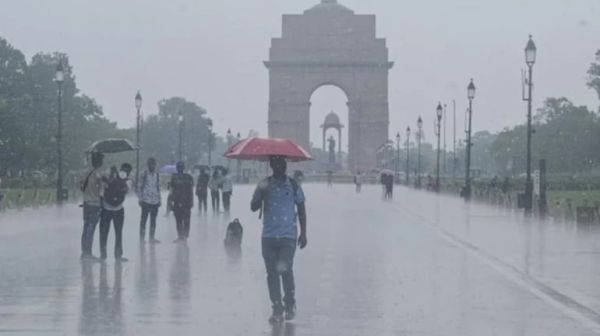
Preparations have been completed across the country to celebrate the national festival of 80th Independence Day with great enthusiasm on 15th August, but this time, amidst the celebrations of Independence Day, monsoon clouds are also going to rain heavily. India Meteorological Department (IMD) has issued a widespread alert of severe thunderstorm, lightning and torrential rain in more than 16 states of the country for tomorrow i.e. Saturday, 15 August 2026. From the main ceremony at the Red Fort in the capital Delhi to Uttar Pradesh, Bihar, Punjab, Haryana and Madhya Pradesh, there will be clouds. According to the Meteorological Department, the weather system has become extremely aggressive due to the deep low pressure area formed in the Bay of Bengal and the active monsoon trough moving towards the north-west simultaneously. Especially in the 3 major sensitive areas of hills and plains, the Meteorological Department has issued 'Orange Alert' and advised people to be extremely cautious and avoid unnecessary travel. IMD's Orange Warning: Danger of heavy to very heavy rain in these 3 major areas Meteorologists have warned that there will be a serious risk of heavy waterlogging, swollen rivers and landslides in these three major areas on August 15: 1. Hilly districts of Himachal Pradesh and Uttarakhand: Himachal's Kangra, Mandi, Shimla, Kullu, Chamba and Sirmaur along with Uttarakhand's Dehradun, Nainital, There is an orange alert for torrential rain and lightning in Tehri and Uttarkashi. There is a possibility of flash floods in these areas, landslides on the National Highway and disruption of communication routes. 2. East Madhya Pradesh and North Chhattisgarh: Due to the influence of the depression moving from Jharkhand, there is an orange alert of very heavy rainfall (115 mm to 204 mm) in the northern divisions of East Madhya Pradesh and Chhattisgarh. This may increase the water level in the low-lying areas of Narmada, Son and Mahanadi basins. 3. South-East Rajasthan and Western Ghats region: Orange alert of heavy rain with thunder and lightning has been issued in Kota, Udaipur, Bharatpur divisions of Rajasthan and many parts of Kerala and Coastal Karnataka of South India. How will the weather be in Delhi-NCR on Independence Day? Shadow of rain on Red Fort celebrations: There will be dense dark clouds in the sky in the capital Delhi and NCR (Noida, Ghaziabad, Gurugram, Faridabad) from the morning of 15th August. According to the Meteorological Department, intermittent moderate to heavy rains will continue in Delhi-NCR from August 15 to 19. Light to moderate rain and strong winds at a speed of 30 to 40 km per hour are expected during the Independence Day parade and flag hoisting on the morning of August 15. Tomorrow's maximum temperature in Delhi may be recorded between 32 to 33 degrees Celsius and the minimum temperature may be around 25 degrees Celsius. There will be a drop in temperature due to rain, but due to humidity level being 80 to 90 percent, people may have to face stickiness. Delhi Traffic Police and administration have declared high alert to deal with the waterlogging situation in low-lying areas like ITO, Minto Bridge, Dhaula Kuan and Kashmere Gate. Heavy rain in Uttar Pradesh till August 18: Alert from western to eastern UP. Monsoon has become fully active in Uttar Pradesh. According to Meteorological Center Lucknow, both western and eastern divisions of the state will see widespread rain from August 15 to 18: Western UP: Meerut, Saharanpur, Shamli, Muzaffarnagar, Baghpat, Bijnor, Moradabad, Bulandshahr, Aligarh and Agra have been warned of torrential rain and thunderstorms on August 15 and 16. Eastern UP: There is a possibility of moderate to heavy rain with thunderstorms in Lucknow, Kanpur, Ayodhya, Varanasi, Prayagraj, Gorakhpur, Bhadohi, Azamgarh, Basti and Deoria from August 15 to 19. Farmers have been given strict instructions to avoid going to open fields and taking shelter under trees during lightning. Bihar, Jharkhand and Odisha: Water level of rivers near danger mark. Rain is becoming a disaster in Eastern India. Due to the monsoon system over Jharkhand and West Bengal, Swarnarekha, Kharkai and Koel rivers are in spate and there is a danger of flood in many low-lying areas of Jamshedpur and Palamu. In Bihar, there is a yellow alert of heavy rain with strong winds and thunderstorm in Patna, Gaya, Bhagalpur, Purnia and Muzaffarpur from 15 to 17 August. Very heavy rain is expected in many parts of the state on August 17 and 18. In Odisha too, heavy rains will continue in the coastal and interior districts till August 16. Latest trend of monsoon in Punjab, Haryana and Rajasthan Punjab and Haryana: On August 15, heavy rain along with strong thunder will be seen in Ambala, Karnal, Rohtak and Panchkula of Haryana including Patiala, Ludhiana, Jalandhar, Amritsar and Chandigarh of Punjab. There will be an alert of extremely heavy rain in Punjab on August 17. Rajasthan: There will be some reduction in the intensity of rain in Western Rajasthan (Jaisalmer, Barmer, Bikaner) from August 15, but moderate to heavy rain is likely to continue in Jaipur, Bharatpur, Dausa, Sawai Madhopur and Hadoti region of Eastern Rajasthan on August 15 also. Red and Orange Alert in Hill States: Advisory for tourists and local people Continuous torrential rains in Himachal Pradesh, Uttarakhand and Jammu and Kashmir have badly affected life. Himachal Pradesh: The State Disaster Management Authority (SDMA) and the Meteorological Department have appealed to tourists not to go near rivers, waterfalls and vulnerable hill slopes. Many connectivity routes are closed due to landslides in Kangra, Mandi and Kullu. Uttarakhand: Due to the fear of landslides on the Chardham Yatra route (Badrinath, Kedarnath, Gangotri and Yamunotri Highway), the administration has been put on 24-hour alert mode. The extent of rain in the state may increase further on 16 and 17 August. Analysis of meteorologists: Why did this terrible system become active on August 15? According to meteorologists, a rare meeting of two major weather systems is currently taking place over North and Central India: First, a depression originating from the Bay of Bengal is moving towards North-West India through the border of Jharkhand and Chhattisgarh. Second, the monsoon trough is currently moving southwards from its normal position and passing through the center of this depression. Along with this, due to the influence of Western Disturbance, moist winds coming from the Arabian Sea are colliding with each other over North India. Due to this three-stage seasonal cyclone, there is heavy moisture and instability in the atmosphere, which is causing sudden strong thunderstorms and torrential rains. Before leaving the house on Independence Day, keep these 5 things in mind. The Meteorological Department and Disaster Management have issued important safety instructions for the citizens participating in the programs and flag hoisting ceremonies of August 15: Keep an umbrella, raincoat and waterproof bag with you while leaving the house. Avoid flooded underpasses and low lying roads while driving. Do not stand in open fields, under electric poles, hoardings and big trees during lightning or strong thunderstorms. People traveling to hilly areas should proceed only after seeing live satellite weather reports and traffic updates from the local administration. Farmers should make proper arrangements for drainage in their fields and postpone spraying of pesticides for a few days.
-
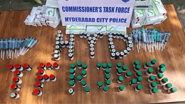
Three arrested as Hyderabad police busts Mephentermine racket
-
KTR pushed sister out of home over property, alleges CM Revanth

-
Mahindra Scorpio Lifestyler First Look: Should You Wait For This Pickup?

-
Top 10 | ABP LIVE Evening Bulletin: Top News Headlines from 16 August 2026 - Evening

-
Lionel Messi misses third straight penalty as Inter Miami are thrashed 4-1 by Nashville