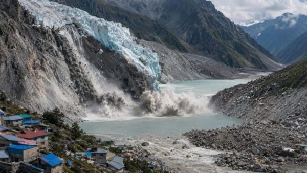
The Himalayas are called the 'Third Pole' of the Earth, but due to global warming and uncontrolled human interference, this beautiful mountain range is now standing at the brink of a serious environmental and geological crisis. Due to rapid melting of glaciers and heavy landslides in high mountain areas, the natural courses of rivers are being blocked. When debris weighing hundreds of tons, huge rocks and ice fall into narrow valleys, they form a rough natural dam, blocking the flowing water, behind which millions and millions of liters of water accumulates. According to scientists and disaster management experts, these temporary lakes are no less than a ticking 'water bomb' for the mountains. What is the deadly science of GLOF and landslide dams? In the language of geology, this phenomenon is mainly understood in two forms: Glacial Lake Outburst Flood (GLOF): When glaciers on high mountains melt and retreat, leaving behind a high pile of soil, boulders and rocky debris, which is called 'moraine'. Behind this moraine, water from the melted ice fills and forms a proglacial lake. When this raw moraine wall breaks due to heavy water pressure, earthquake shock or avalanche, millions of cusecs of water descends at tremendous velocity. Landslide Dammed Lake: Due to rain or seismic activity, when an entire hill collapses and completely stops the flow of the river, the water of the river stagnates there. This dam made of soil and stones is not a permanent structure. As the water pressure increases, this dam collapses in the blink of an eye and brings a flood of destruction. Over 24,000 lakes identified, in over 200 'ultra-sensitive' red zones According to recent satellite studies by the Wadia Institute of Himalayan Geology and ISRO, over 24,400 glacial and supraglacial lakes have been mapped across the entire Hindu Kush Himalayan region. Of these, more than 10,000 lakes are spread over an area larger than 0.01 square kilometre. The most shocking thing is that about 221 lakes have been placed in the extremely dangerous and unstable category (High-Risk GLOF Threat). These include the lakes of Kosi Basin, Teesta Basin, Chenab, Jhelum, Beas and Manas Basin, where even the slightest deviation can completely submerge settlements downstream. Not just water, it wreaks havoc in the form of a 'tsunami of mud, boulders and silt'. The flood that occurs due to the breach of temporary lakes is 100 times more destructive than a normal flood. Due to the altitude and steep gradient, the speed of water reaches 50 to 80 kilometers per hour. This flow brings with it huge rocks, trees, sand and silt (Debris Flow). This heavy debris washes away huge concrete bridges, concrete houses, roads and tunnels like straw. The Kedarnath tragedy of 2013, the Chamoli Rishiganga disaster of 2021 and the Sikkim South Lhonak lake breach of 2023 are direct examples of this horror. Deep threat to Himalayan infrastructure, hydropower projects and human settlements. Hydroelectric projects (Hydroelectric Dams) built in river valleys, highways, railway networks and dense residential settlements are the direct targets of flash floods of these lakes. In narrow valleys, when water suddenly rises by 30 to 40 feet, people do not even get 5 to 10 minutes to run to safe places. Not only the hill states like Uttarakhand, Himachal Pradesh, Ladakh and Sikkim, but also the plains of Bihar and Uttar Pradesh through the rivers flowing from Nepal come under direct threat of this uncontrolled deluge. Scientific measures and early warning system to avoid this natural disaster Scientists are clear that to avoid this 'death trap' of nature, immediate and long-term policy steps have to be taken: Satellite real-time monitoring: 24×7 monitoring of water levels of sensitive lakes and moraine dams through satellite and drones. Early Warning System (EWS): Installation of automatic sensors and sirens in the upper reaches of rivers, which can send immediate alerts to downstream settlements if the water level rises suddenly. Controlled drainage (siphoning): To keep the water level below the danger mark through large pipes and pumps from lakes that have become too dangerous. Sensitive zoning: Strict legal prohibition on heavy construction, unplanned blasting and indiscriminate hotel-resort construction in high-risk flood plain areas.
-
Hyderabad: Man dies after being hit by car twice in one night

-
Man hangs self in Chanchalguda jail after wife fails to get bail

-
Telangana govt plans bureaucratic overhaul after SIR exercise
-
CJI row: NALSAR body backs NLSIU students after convocation axed

-
Awarapan 2 to stream on Prime Video: OTT release date details