Brits melting in this weekend's scorching heatwave conditions are warned more hot weather could come in July.
The country is set to bask in 30C heat today (Sunday, June 29) with the mercury set to soar to up to 34C by tomorrow. Thermometers are set to show a drop by the middle of next week, but that may not be the end of it.
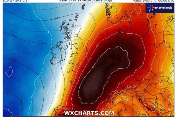
That's according to the Met Office's long-range forecast, which pinpoints mixed conditions for July, including thunderstorms. But the leading UK forecaster has, however, revealed "temperatures are expected to be above average for most areas" before August hits.
The Met Office said: "Temperatures will generally rise through this weekend for those in the south, with in excess of 30C possible in the southeast or East Anglia on Sunday, and even higher than that on Monday, in what is currently likely to be the peak of this heatwave for many."
READ MORE: UK households told to shut windows and curtains facing one direction on Sunday
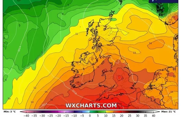
Weather maps currently show the south-east dropping to the late 20Cs by Wednesday, with temperatures sloping down further during the first few days of July.
In the Met Office's long-range forecast from July 1 to 10, which is updated daily, it says: "A low pressure system runs near or across the northwest of the UK at the start of the period bringing some wetter, windier conditions to the northwest.
"Elsewhere a good deal of dry and very warm or hot weather at first, but it is possible the odd thunderstorm could develop in response to the heat before it turns cooler and fresher from the west by the middle of next week. Beyond this, conditions look like being rather changeable, with some drier spells but also some spells of rain and wind."
But it doesn't rule out more hot weather, and continues: "There is also the chance of further very warm or locally hot and humid weather, as brief bursts of hotter air encroach from the continent, but probably fairly short-lived. Should these occur they bring with them the threat of thunderstorms."
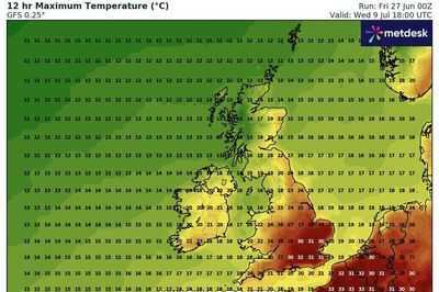
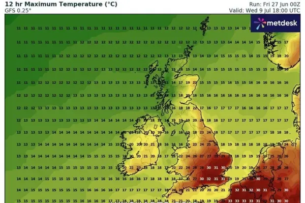
Maps, which are subject to change, show temperatures steadily rising by Monday, July 7 to 26C in regions such as Kent and Sussex. By July 8, 30C could be achieved once again in central, southern parts of England, including Greater London and it could even rise by another 2C by the following day.
In the Met Office's broader outlook for July, which goes up to the 25th, it added on Friday (June 27): "Conditions will likely continue to be changeable through much of July. The wettest and windiest conditions look most likely towards the northwest with a risk of some heavy rain at times, especially over hills.
"Southern and eastern areas are most favoured for longer drier and more settled spells, although even here some rain or showers will be likely, perhaps heavy and thundery at times. There are signs of more widely settled weather during the second half of July, however this signal is very tentative.
"Temperatures are expected to be above average for most areas, especially towards the southeast where there will be an ongoing chance of some very warm or hot conditions at times."
-
What To Expect From The 2025 Hyundai Venue Facelift: Bold Design, Premium Features, And Unchanged Engines

-
'Babu Bhaiyya' Takes U-Turn: Paresh Rawal Confirms Return To Hera Pheri 3

-
Make Your Brand The First Choice, Not The Cheapest Option

-
Iran calls on UN to recognise US, Israel as initiators of 'aggression'

-
Households warned over one weed with yellow flowers thriving in shady gardens