Severe weather alert: Coastal Tamil Nadu, Puducherry and Andhra to face heavy rains, strong winds
ETimes | December 3, 2025 5:39 PM CST

Large parts of India are set to witness a combination of heavy rain, plunging temperatures, dense fog and squally winds as a weakening depression—remnant of Cyclonic Storm Ditwah—continues to influence weather patterns across the southern peninsula. The (IMD), in its All India Weather Summary and Forecast Bulletin issued at 20:11 IST on December 2, warned of significant rainfall activity over Tamil Nadu, Puducherry, Andhra Pradesh, Rayalaseema and Kerala, alongside the onset of cold wave conditions in several northern and central states in the days ahead.
Heavy rainfall over southern states as depression moves southwestThe primary weather system driving these conditions is the depression that was earlier Cyclonic Storm Ditwah. Its proximity to the coast has already triggered widespread rainfall across the southern peninsula. According to IMD, many areas in Tamil Nadu, Puducherry & Karaikal, Andhra Pradesh, Rayalaseema, South Interior Karnataka and Kerala received sustained moderate rainfall. North coastal Tamil Nadu is likely to see heavy rainfall on December 3. Southern coastal Andhra Pradesh and Rayalaseema are also expected to continue receiving significant rainfall.
Kerala is set to witness heavy showers on both December 3, with thunderstorms likely to accompany the system.
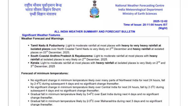
Wind, sea and fishermen warnings in placeIMD warned that squally winds associated with the weakening system will continue to pose a risk to coastal communities and those at sea. Winds reaching speeds of 45–55 kmph gusting to 65 kmph are expected along the southwest and adjoining westcentral Bay of Bengal, stretching along the coasts of Tamil Nadu, Puducherry and south Andhra Pradesh.
Sea conditions are forecast to remain very rough to rough over large stretches of the Bay of Bengal and the Tamil Nadu–Puducherry–South Andhra Pradesh coastline until the morning of December 3. Authorities have issued an absolute suspension of fishing activities across all affected maritime zones. Those already at sea have been advised to steer clear of these waters until conditions improve tomorrow morning.
Falling temperatures and cold wave set to intensify in North and Central IndiaWhile southern states grapple with heavy rain and coastal hazards, parts of North, Northwest and Central India are bracing for a steep drop in minimum temperatures.
IMD has forecast:
Dense fog expected across eastern and northeastern statesDense fog conditions are very likely in the early morning hours across:
Flash flood alert for Andhra Pradesh, Tamil Nadu and PuducherryThe risk of flash floods remains moderate over select watersheds in:
Impact and precautions
According to IMD, the ongoing and upcoming weather systems could trigger:
The IMD forecasts isolated to scattered rainfall across the Western Himalayan region, South Kerala, South Tamil Nadu and island territories during the next three days. Thunderstorms with lightning are expected to persist across southern coastal and interior districts until December 6.
As Cyclonic Storm Ditwah’s remnants continue to weaken, the southern and southeastern coastlines are expected to gradually see improved sea and wind conditions after Wednesday morning.
Heavy rainfall over southern states as depression moves southwestThe primary weather system driving these conditions is the depression that was earlier Cyclonic Storm Ditwah. Its proximity to the coast has already triggered widespread rainfall across the southern peninsula. According to IMD, many areas in Tamil Nadu, Puducherry & Karaikal, Andhra Pradesh, Rayalaseema, South Interior Karnataka and Kerala received sustained moderate rainfall. North coastal Tamil Nadu is likely to see heavy rainfall on December 3. Southern coastal Andhra Pradesh and Rayalaseema are also expected to continue receiving significant rainfall.
Kerala is set to witness heavy showers on both December 3, with thunderstorms likely to accompany the system.
Wind, sea and fishermen warnings in placeIMD warned that squally winds associated with the weakening system will continue to pose a risk to coastal communities and those at sea. Winds reaching speeds of 45–55 kmph gusting to 65 kmph are expected along the southwest and adjoining westcentral Bay of Bengal, stretching along the coasts of Tamil Nadu, Puducherry and south Andhra Pradesh.
Sea conditions are forecast to remain very rough to rough over large stretches of the Bay of Bengal and the Tamil Nadu–Puducherry–South Andhra Pradesh coastline until the morning of December 3. Authorities have issued an absolute suspension of fishing activities across all affected maritime zones. Those already at sea have been advised to steer clear of these waters until conditions improve tomorrow morning.
Falling temperatures and cold wave set to intensify in North and Central IndiaWhile southern states grapple with heavy rain and coastal hazards, parts of North, Northwest and Central India are bracing for a steep drop in minimum temperatures.
IMD has forecast:
- No significant change in minimum temperatures over Northwest India for the next 24 hours, followed by a sharp fall of 2–4 degrees Celsius over four subsequent days.
- Similar conditions are expected across Central India, where temperatures will drop by 2–3 degrees Celsius.
- East India will experience a gradual fall of 3–4 degrees Celsius over the next four days.
- Maharashtra will see a cooling of 2–3 degrees Celsius over the next three days.
- Northeast India will experience no major change for three days, followed by a dip of 2–3 degrees Celsius.
Dense fog expected across eastern and northeastern statesDense fog conditions are very likely in the early morning hours across:
- Himachal Pradesh
- Assam and Meghalaya
- Nagaland, Manipur, Mizoram and Tripura
- Odisha on December 3 and 4
Flash flood alert for Andhra Pradesh, Tamil Nadu and PuducherryThe risk of flash floods remains moderate over select watersheds in:
- Nellore district (Coastal Andhra Pradesh)
- Tirupati district (Rayalaseema)
- Chennai and Tiruvallur districts (Tamil Nadu–Puducherry–Karaikal region)
Impact and precautions
According to IMD, the ongoing and upcoming weather systems could trigger:
- Uprooting of small trees and breaking of branches
- Waterlogging in urban and low-lying areas
- Flooding of evacuation routes and damage to salt pans
- Reduced visibility due to heavy rain
- Traffic disruption
- Localised landslides or mudslides in vulnerable locations
- Stay indoors and avoid taking shelter under trees
- Move to safer locations if conditions worsen
- Avoid motorboat travel
- Regulate tourism, transport and offshore activities
- Remain updated with local weather advisories
The IMD forecasts isolated to scattered rainfall across the Western Himalayan region, South Kerala, South Tamil Nadu and island territories during the next three days. Thunderstorms with lightning are expected to persist across southern coastal and interior districts until December 6.
As Cyclonic Storm Ditwah’s remnants continue to weaken, the southern and southeastern coastlines are expected to gradually see improved sea and wind conditions after Wednesday morning.
READ NEXT
-
Railways: Forget the old method of buying Tatkal window tickets, Railways has taken a big decision..
-
EPS 95 Pension: Will the minimum pension increase from ₹1,000 to ₹7,500? What did the government say in Parliament?

-
Money Tips: Invested 8000 rupees every month and became 1 crore in 15 years, this fund made a lot of money..

-
Government Schemes for Senior Citizens: A major announcement for senior citizens, now treatment, travel, and pensions are all easier.

-
8th Pay Commission: Will salary and pension increase from January 2026? Every employee needs to know these updates..