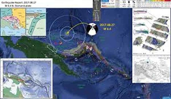
Bismarck Sea: An earthquake measuring magnitude 6.1 struck the Bismarck Sea on Tuesday, drawing attention to the high seismic activity of the Australia–Pacific region. According to official seismic monitoring data, the tremor occurred at a shallow depth, which increases the likelihood of noticeable ground shaking and aftershocks. Although no immediate reports of damage or casualties were released, such events highlight the constant geological instability of this part of the world.
Earthquake Details and Initial Observations
The seismic event was recorded at a depth of approximately 10 kilometers beneath the Earth’s surface. Shallow earthquakes are often considered more hazardous because the seismic energy has less distance to dissipate before reaching the surface. As a result, ground motion can feel stronger, even when the magnitude is moderate compared to deeper earthquakes.
The epicenter was located in the Bismarck Sea, a region north of Papua New Guinea that frequently experiences seismic disturbances. Due to the shallow focus of the quake, scientists have warned that aftershocks may follow in the coming days or weeks. Such aftershocks can sometimes be strong enough to cause additional concern for nearby coastal and island communities.
Why Shallow Earthquakes Are More Dangerous
Shallow-focus earthquakes typically cause more intense surface shaking than deep-focus events. When seismic waves originate close to the surface, buildings, infrastructure, and natural landforms absorb more energy. This can lead to structural damage, landslides, and in coastal areas, even the potential for localized tsunamis if underwater displacement occurs.
In regions like the Bismarck Sea, where many communities rely on coastal settlements and maritime activities, even moderate earthquakes can disrupt daily life. Ports, communication lines, and transportation networks are particularly vulnerable to repeated seismic stress.
Tectonic Setting of the Australia–Pacific Boundary
The Bismarck Sea lies near one of the most complex and active tectonic boundaries on the planet. The Australia–Pacific plate boundary stretches for more than 4,000 kilometers along the northern margin of the Australian Plate. This boundary extends from the Sunda Trench near Java in the west to the Solomon Islands in the east.
The eastern segment of this boundary alone spans over 2,300 kilometers. It runs westward from the Coral Sea and the northeastern edge of the Australian continent until it meets the eastern coast of Papua New Guinea. The dominant geological process in this zone is the northward subduction of the Australian Plate beneath the Pacific Plate, a movement that continuously builds stress within the Earth’s crust.
Seismic Activity Along Major Trenches
One of the most active features in this region is the South Solomon Trench. Along this trench, the Australian Plate converges with the Pacific Plate at a rate of nearly 95 millimeters per year. This relatively fast rate of movement makes the area highly prone to powerful earthquakes.
Historical seismic records show that large earthquakes are common along this trench. Since the year 1900, at least thirteen earthquakes with magnitudes of 7.5 or higher have been documented. These events are primarily linked to subduction-related tectonic processes, where one plate is forced beneath another.
Historical Mega-Earthquakes and Tsunami Risk
The seismic history of the region includes several devastating earthquakes. One of the most significant occurred on April 1, 2007, when a magnitude 8.1 megathrust earthquake struck the western end of the South Solomon Trench. This event triggered a tsunami and resulted in the loss of at least 40 lives.
Notably, this was not an isolated incident. Similar magnitude 8.1 megathrust earthquakes were recorded in 1939 and 1977, indicating a recurring pattern of large seismic releases along this subduction zone. Such history underscores the long-term tsunami risk for coastal populations in the southwest Pacific.
Complex Plate Interactions Near New Guinea
Further east, near the New Britain Trench, the tectonic environment becomes even more complex. Several microplates interact in this area, creating a network of geological movements. One notable feature is the north–south oriented seafloor spreading in the Woodlark Basin, located south of the Solomon Islands.
Despite these complex motions, the overall geological trend remains the same: Australian-affiliated lithosphere continues to subduct beneath Pacific-affiliated lithosphere. This ongoing process is responsible for many of the large and great earthquakes recorded east of New Guinea.
Concentration of Major Earthquakes
Seismic studies show that many powerful earthquakes are concentrated near the cusp of the trench south of New Ireland. Since 1900, at least thirty-three earthquakes with magnitudes of 7.5 or greater have been recorded in this broader region. Among them were three shallow thrust fault earthquakes of magnitude 8.1 in the years 1906, 1919, and 2007.
This pattern confirms that the Bismarck Sea and its surrounding areas remain one of the most seismically active zones on Earth. Continuous monitoring and preparedness are essential to reduce risks associated with future earthquakes.
-
ICC T20 World Cup 2026: Bangladesh remain adamant on decision in spite of deadline, refuse to play in India

-
Ravi Kishan Pushes for National Awards recognition for television: ‘I will write to the ministry’

-
Kiara Advani and Kartik Aaryan face backlash after flyer alleges cold behaviour on Jaipur–Mumbai flight: ‘Ganda Sa expression diya’

-
This Dryrobe dog coat has been a game-changer for winter walks

-
How to grow avocado at home from seed: Foolproof guide to grow exotic fruits