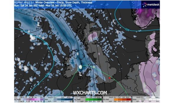
Mutiple regions of England and Scotland are could be under snowclouds in hours, and on occasions when there's heavy snowfall the Met Office recommends taking some surprising precautions - including checking your smoke alarms. Forecast data collected by WXCHARTS.COM shows snowfall staring to appear in Britain from around 6pm on Monday, January 25, affecting parts of Northern Ireland, northern Wales, and Scotland, as well as rainfall in various areas including Scotland, Northern Ireland, South and South West England.
By 9pm households in northwest England, Scotland, and Wales may be seeing snowfall as rain continues across Wales and coasts in the south of England. Areas England that could be seeing around 1mm of snow falling per hour in some areas at this time appear to include:
- Stoke-on-Trent
- Cheshire East
- Derbyshire
- South Yorkshire
- Greater Manchester
- West Yorkshire
- North Yorkshire
- Lancashire
- Durham
- Westmorland and Furness
- Cumberland
In Scotland, local authorities that could be seeing snow then include:
- Argyll & Bute
- Sterling
- Perth & Kinross
- The Highlands
- Aberdeenshire
- Angus
The map also suggests an area intersecting around where the boundaries of the Highlands, Perth and Kinross, Angus, and Aberdeenshire could also be seeing freezing rain at this time.
In Northern Ireland, also appears to be a patch of snowfall covering West Tyrone, Mid Ulster and East Londonderry at this time, with rainclouds covering the rest of the country.
Maps suggest some areas within them could be seeing as much as 1mm/hr of snow, which meets the Met Office's definition of heavy snow.
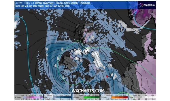
Snow looks set to continue on Tuesday, possibly covering large parts including in Northern Ireland, the Midlands and northwest of England, and parts of Scotland, as rain continues to pelt down in some areas.
It's worth noting that the list is not an exhaustive picture of all the areas that could be affected, and it's best to check official channels for the latest guidance.
British Gas provides a range of tips for people in heavy snow conditions, including improving insulation and protecting your pipes.
Among the more surprising tips is checking your smoke detectors due to the increased risk of house fires during cold weather.
The firm says it's down to more people resorting to "alternative heat sources like log burners and electric heaters to keep the chill off".
"So it's vital that you regularly test your smoke alarms and C02 detectors to make sure they're working properly," the firm says. "And always clear any ventilation outlets after a snowfall to keep them working efficiently." You can find its snow safety advice in full here.
The Met Office's current 3 to 5-day forecast covering Monday, January 26, to Wednesday, Jan 28 anticipates it will remain "unsettled throughout, with bands of rain moving north and east across the country, particularly on Tuesday when another deep area of low pressure approaches from the southwest". "Feeling cold," it adds.
It comes as multiple yellow warnings have been issued for rain, with one in effect covering multiple local authorities across two regions in Scotland, and another covering a number in South West England and Wales. A further warning covering the whole of Northern Ireland will be in place from 6pm.
Additional warnings will be in place in the coming days. You can find the latest warnings and guidance here.
-
Happy Republic Day 2026 Images: 50+ Wishes, quotes, greeting card messages, SMS, WhatsApp & Facebook status

-
Crowds flock to Tokyo zoo to see pandas before they leave for China

-
Trump escalates Canada-US trade standoff with threat of 100 percent tariffs over China relations and recent EV deal

-
NASA study using 50-year-old Apollo Moon samples suggests Earth’s water may not have come from meteorites
-
‘We need your help’: Carlos Alcaraz vs Tommy Paul Australian Open match halted due to emergency, officials respond swiftly; here's what happened