Parts of the UK are bracing for late winter snow accompanied by plunging temperatures of up to -4C, according to new weather maps. Forecasts produced by WXCharts show a band of cold and snowy weather moving across the country in early February, as systems from the Atlantic push in from the west. A stretch of northern and central England is set to bear the brunt of the icy conditions, alongside most of Scotland, from around 6am on Thursday, February 5.
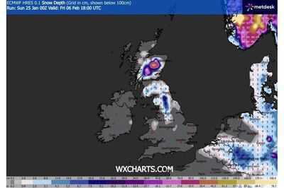
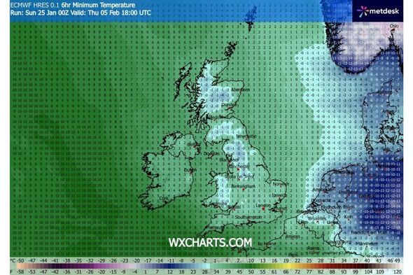
Snow depths could reach 10cm around Inverness, while around half of England, from Carlisle down to Stoke-on-Trent, could be painted white during the same period, according to predictions. Temperatures are also expected to dip during the first few days of February, with the mercury hovering at or just below 0C for much of the country, and dropping to -4C in Scotland on the evening of February 5.
The snow storm could set the tone for next month, with flurries set to continue over the following days and depths reach 18cm around Bradford and Leeds on Friday, February 6, forecasts suggest.
In its own separate long-range forecast different to that of WXCharts, the Met Office's predicts that Atlantic weather systems will attempt to push in from the west between January 30 and February 8, bringing "spells of rain and strong winds".
"Rain may be heavy and persistent, especially in the south and west," it adds. "Where fronts from the southwest do reach the cold air towards the northeast, there is the risk of some snow, most likely across hills, but perhaps extending to lower areas at times."
It will follow a disruptive few weeks of weather for parts of the UK in early 2026, with Storm Ingrid wreaking havoc on southern regions and even washing away part of a historic Devon pier.
Today:
Outbreaks of rain and some heavy showers, with hill snow likely in parts of northeast Scotland. Some brighter spells in the south and light winds in most areas.
Tonight:
Cloudy with occasional rainfall and wintry showers likely in the northeast. Mist and fog possible in the southeast.
Monday:
More rain for parts of northeast England and east Scotland, turning wintry in hilly areas. Strong winds and rain hitting western regions before spreading eastwards.
Outlook for Tuesday to Thursday:
Cold temperatures and unsettled conditions, with rain, showers and hill snow possible. Another deep area of low pressure arriving on Tuesday and bringing strong winds across the country.
-
R-Day: Punjab Police carry out flag marches in sensitive areas

-
From folk traditions to social service: Five Gujaratis honoured with Padma Shri

-
Lloyds and Halifax closing 54 UK branches - full list of locations affected

-
Incredible train line between two African countries rebuilt after 100 years

-
Grateful, happy, says SNDP Yogam leader on receiving Padma Bhushan honour