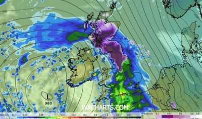
Weather maps have suggested the UK is set for a large blanket of snow later this month. A WXCharts map shows a huge purple blog stretches from the south of Scotland, the entirety of Northern Ireland, which has six counties, the north of Wales and much of northern England on February 16 at 12pm. The counties impacted, according to the forecast, are set to be: Northumberland, Durham, Cumbria, North Yorkshire, South Yorkshire, West Yorkshire, East Yorkshire, Lankashire, Cheshire, West Midlands, Shropshire, Derbyshire, Lincolnshire and Leicestershire. Warwickshire and Rutland may also be impacted. Seven counties in Wales - Wrexham, Flintshire, Powys, Gwynedd, Denbighshire, Conwy and Anglesey - look to be snowed on, too.
In Scotland, the snow blanket seems to include the Scottish Borders, Dumfries and Galloway, South Ayrshire, East Ayrshire, South Lanarkshire, East Lothian, Argyll and Bute, Sterling and seven of the other tiny administrative areas to the west of Edinburgh. The Met Office said in its own separate forecast for Sunday, February 8, to Wednesday, March 4: "Cyclonic patterns are expected to dominate across the UK during mid-February.
"Frontal systems over the Atlantic are likely to approach the UK at times, tending to become slow moving as they encounter a blocking area of high pressure to the northeast.
"This will result in showers or longer spells of rain spreading across the UK, these heavy at times. Rainfall amounts will probably be highest in parts of the west, including across areas already sensitive to flooding.
"As these bands of rain spread northwards, snow is possible across northern England and Scotland, mainly over high ground.
"Strong winds could develop in places, especially coasts.
"Temperatures will probably be close to normal overall, with any cold conditions more likely in the north.
Meteorologists look at three main indicators when forecasting snow, the Met Office adds: where the air has come from, very heavy precipitation and when warm air meets cold air.
Specialists add: "If air has come from a warmer area, or has spent a long time over mild water, then it would be harder to generate snow.
"If it's coming from a cold region, often the north, then there's a chance of snow being a possibility."
Those in the know highlight that most precipitation in the clouds starts off as snow or "supercooled" raindrops, but this often melts before it hits the ground.
"However, in winter, intense precipitation can keep temperatures lower closer to the ground, increasing the chance of heavy rainfall turning into snow," the Met Office says.
"Presenters often talk about weather fronts between warm and cold air," it adds.
"In the winter, these fronts can introduce the moisture and conditions for snow to fall.
"There's often a fine line between who sees snow and who sees rain, which is one of the reasons forecasting snow can be difficult."
-
From runway to global spotlight: LAAM Fashion Week 2026 concludes in style

-
Apply these things mixed with ice, your skin will glow…

-
Mom Infuriated By Note Husband Left For Kids Before His Business Trip

-
Your Daily Love Horoscope For Wednesday, February 4, 2026

-
Southeast Asia’s largest economy receives highest number of Chinese tourists in six years