
Weather maps are pointing to a spell of wintry weather sweeping across the UK, with snow potentially reaching as far south as parts of England by midweek. According to the latest projections from WXCharts, generated on Monday (May 4), snowfall could arrive on Wednesday (May 6) and continue for several hours, with some areas seeing up to nine hours of wintry conditions.
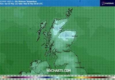
The change in weather is being linked to a push of colder air moving into the country, replacing the milder conditions experienced recently. As this colder system spreads, rain may increasingly turn to snow, particularly across northern regions and higher ground, though some southern areas could also be affected. One map focusing on 'Minimum Temperatures' at 6am on May 6 shows the coldest air concentrated across northern parts of the UK, with much of Scotland turning close to or even below freezing.
In the Scottish Highlands and inland in particular, temperatures are expected to dip to as low as -3C, with temperatures around -1C or 0C closer to Aberdeen. Further south, values are still expected to be chilly, with parts of northern England struggling to rise much above 4-5C during the early hours.
- Snooker scores LIVE: Shaun Murphy vs Wu Yize takes another twist in £500K Crucible final
- Keir Starmer has just shown his true colours and slapped every Brexit voter in the face
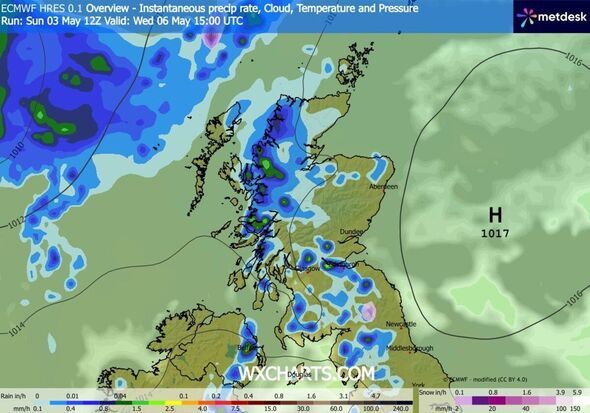
Alongside the drop in temperature, a second chart showing precipitation and pressure suggests a band of wintry showers moving through central and northern regions of Scotland and even as far south as North England. A substantial flurry is predicted to descend on an area inland of Newcastle, bringing with it a few inches of snow per hour by 3pm on Wednesday. A third map predicting conditions a few hours later suggests a subsequent, even larger, wintry shower arriving in the north of Scotland, with even heavier flurries.
Despite the cold start, the weather is predicted to remain dry for much of the morning, with clear skies across the country. However, as the day progresses, the situation will change dramatically. By the afternoon, rain will sweep in from the west, bringing wet conditions to the northernmost parts of the UK. While snowfall is expected in northern regions earlier in the day, rain will eventually reach other parts of the country, turning into heavier showers as temperatures remain chilly.
Separately, the Met Office's most up-to-date outlook for Wednesday (May 6) to Friday (May 8) reads: "Noticeably cooler for all at first, turning warmer towards the weekend. Some showers at times, though these lighter and fewer than the weekend with sunny spells emerging as well."
This comes after Tuesday will be "dry for many, with variable amounts of cloud and sunny spells," according to the Government agency. "Showery outbreaks of rain continuing to push south across northern areas. Brighter conditions follow as colder air arrives," it added.
Regarding its long-range forecasting, the Met Office warns: "When looking at forecasts beyond five days into the future, the chaotic nature of the atmosphere begins to play a larger part - small events currently over the Atlantic can have potentially significant impacts on our weather in the UK and Ireland in several days' time".
-
India to testify at USTR overcapacity probe on May 8

-
Saffron wave deepens erosion of secular norms

-
Last Chance to Apply for Delhi University's BA LLB (Honours) Program

-
Success of swamp deer translocation in Madhya Pradesh could help restore population

-
'Vijay opened people's eyes': In Chennai, jubilation outside one party office, heartbreak at another