New heights in digital governance of Haryana
Chandigarh, 16 May. Haryana has made its mark globally by using modern technology in digital governance and agriculture. Haryana has been honored with the ‘Geospatial Excellence Award’ in the international conference ‘Geospatial World Forum 2026’ held in Amsterdam, the capital of the Netherlands. This award has been given to the state for working on the unique concept of ‘civilian service from space’. Chief Minister Nayab Singh Saini congratulated the team of Haryana Space Applications Center (HARSAC) on this historic achievement and called it a proud moment for the state.
Integrated Platform for ‘Citizen Services from Space’
Giving information about this global achievement, HARSAC Director Dr. Sultan Singh said that due to the visionary leadership of Chief Minister Nayab Singh Saini, Haryana has today become a leader in digital agriculture. HARSAC has developed a ‘Unified Geo Enabled System’ using space technology and remote sensing data. This system provides accurate information about fields and resources without going on the ground. Currently, the system has more than 4,000 active daily users, including policy makers, revenue officials and young innovators.
Satellite monitoring of 1 crore farms
This advanced geospatial platform is proving to be a gamechanger for the rural economy and farmers. Through this, scientific assistance is being provided to more than 15 lakh farmers of Haryana in every crop season and real-time monitoring of more than 1 crore farms of the state is being done. With this technology, crop health, accurate estimation of production, water resources management, analysis of crop insurance claims, market mapping and crop residue management are being accurately monitored. Due to this, corruption has been controlled and the system has become completely transparent.
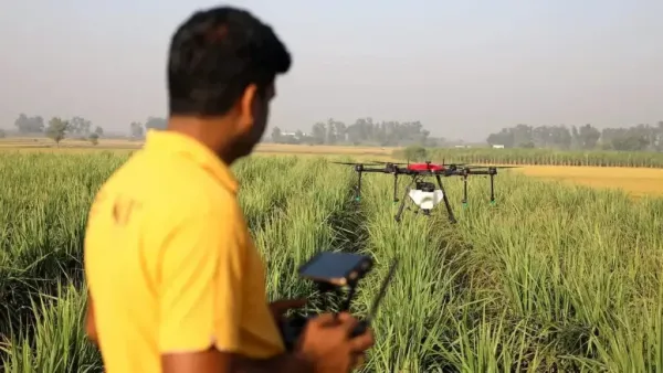
Digital mapping is being done with AI and drone technology
Dr. Sultan Singh said that the international jury has appreciated this work model of Haryana in the field of food security, environmental protection and climate adaptability. HARSAC is no longer limited to agriculture only, but is using satellite images, Geographic Information Systems (GIS), mobile apps, drone surveys and Artificial Intelligence (AI). Through this, comprehensive mapping of the state’s water sources, road network, Panchayat properties and changes in land use is being done, thereby giving scientific direction to the development works.
For more information
Summer earning formula: Moong crop will be ready in 70 days, soil health will also improve
-
IPL 2026: Shreyas Iyer exposed again against RCB, such situation happened for the 5th time in a row

-
Bollywood Accidents: Salman Khan to Aishwarya Rai —6 Stars Who Narrowly Escaped Death

-
Lucknow Hungama: Bulldozer came for Lawyer Chambers Demolition, Advocate clashed with police. Lucknow Lawyers Clash With Police Over Chamber Demolition
-
Finger ink stuck before catching the flight! EC starts major investigation on voting of foreigners in Tamil Nadu – News Himachali News Himachali

-
This technology can provide relief from expensive oil, water will save fuel