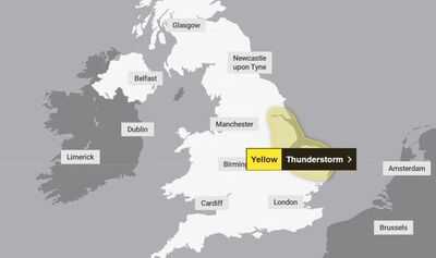

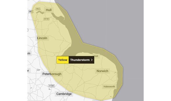
The Met Office has issued a new weather alert for thunderstorms across three UK regions. The yellow weather warning is for the East Midlands, East of England and Yorkshire and Humber from 7am tomorrow, Sunday, July 8.
The warning will be in place until 7pm that day. It comes after a period of scorchingly hot weather with temperatures rising almost as high as 36C at Faversham on July 1, marking the highest the mercury has risen so far this year, according to the government agency.
Britons have been cautioned in the newly announced yellow warning that thunderstorms "may lead to some disruption to travel and outdoor activities".
The national weather service warns residents in areas under the warning to expect "a good chance" that "driving conditions will be affected by spray, standing water and/or hail, leading to longer journey times by car and bus".
Other risks include:
- Probably some damage to a few buildings and structures from lightning strikes
- Some flooding of a few homes and businesses possible, leading to some damage to buildings or structures
- The possibility of delays to train services
- Some short term loss of power and other services is likely
The regions and local authorities affected include:
- East Midlands
- Lincolnshire
- East of England
- Cambridgeshire
- Norfolk
- Peterborough
- Suffolk
- Yorkshire & Humber
- East Riding of Yorkshire
- Kingston upon Hull
- North East Lincolnshire
- North Lincolnshire
In a post on social media flagging the 12-hour warning, the Met Office wrote: "Yellow weather warning issued. Thunderstorms across parts of eastern England Sunday 0700 - 1900. Stay weather aware."
-
Top 4 Highest Team Totals In Test Cricket History

-
Pakistani artists pay tribute to Hazrat Imam Hussain (RA)

-
Is there difficulty in breathing during the rainy season? Know the cause and immediate caution

-
iOS 26 Lockscreen Will Have Live Widgets, Gesture-Based Control & More

-
₹511 crore SSLV deal with ISRO to propel India into commercial space orbit- The Week