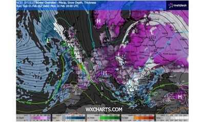
Weather maps show almost the whole of the UK being pelted with snow in the coming days. Forecast data collected by WXCHARTS.COM suggests a battering of blizzards will begin from Wednesday, February 11, beginning with snowfall in parts of Scotland and most of Wales by midday.
Much of Great Britain could be covered in snow by 9am the following day, the maps suggest, with snowflakes falling from the northern tip of the Highlands, down into the East Midlands, along the England's eastern coast, and down across southern England from Ipswich to Plymouth. In an area of Scotland roughly intersecting Perth and Kinross, Angus, and Aberdeenshire, there could be 30cm of snow depth at this time, with between 15 and 17cm in southern England.
Waves of snowfall look set to continue until Tuesday, February 17, when WXCHARTS.COM's forecast range ends. By then, almost about 95% of the UK could be blanketed in white, save for a few coastal areas, the forecast data suggests.
A map showing snow depth at 6am shows some parts of Scotland seeing 2cm on the northern and southern coast, up to much as 54cm around the area of north eastern Scotland worst hit on Wednesday, February 11.
Snowdepths across England look set to range between less than 1cm and 18cm around parts of the North East and northern parts of Yorkshire and the Humber.
Manchester, Birmingham, and London are among the dozens of major cities set to have snow on the ground at this time. Snowdepths in Wales could range between below 1cm and 8cm, in southern areas.
Meanwhile, there could be snow on the ground over most of Northern Ireland, with snow depth ranging from less than 1cm to 4m along the southern border with the Republic of Ireland.
The Met Office's long-range forecast provides an outlook for Friday, February 6 to Monday, March 2, covering the period in question. The national weather service anticipates that frontal systems over the Atlantic, "steered by a south-shifted jet stream, are likely to approach the UK at times, but tending to stall as they encounter a blocking area of high pressure to the north and northeast".
"This will result in further spells of rain at times, falling in areas already sensitive to flooding," it added.
"As these bands of rain spread northwards, some snow will be possible in northern England and Scotland, mainly over higher ground, as they encounter colder air.
"A subtle shift southwards of these areas of low pressure is anticipated during the second week of February, which may allow a greater chance of colder air to spread across larger parts of the UK, including the south, bringing an increased risk of wintry hazards for a time.
It notes that whilst "confidence is lower through this period, a south-shifted jet stream is likely to persist for much of the time, steering areas of low pressure towards and south of the UK".
"This is likely to bring further spells of wet and windy weather, with rain most frequent in the south and west, and perhaps also eastern Scotland, with the driest conditions, relative to normal, in northwest Scotland.
"Some hill snow will be possible at times as the wet weather encounters colder air across northern parts of the UK. Temperatures for the period as a whole will likely be close to average for most parts, but perhaps a little below in the northeast."
However, it's worth noting that long-range forecasts are subject to change and people in areas potentially affected should follow Met Office guidance issued nearer the time if snow occur.
Meanwhile, a yellow weather warning for rain covering local authorities in London & South East England, and South West England is set to come into effect from 6pm today (Monday, February 2), remaining in place until 9pm tomorrow (Tuesday, February 3).
Tuesday will also bring two yellow weather warnings for snow covering local authorities across Scotland from midnight and 6pm.
You can find the latest warnings and guidance on the Met Office website.
-
Are you worried about high uric acid? These 4 fruits rich in Vitamin C will give instant relief!

-
Grammy fashion moments that changed red carpet dressing forever

-
Golden opportunity for writers in xAI

-
Transit of enemy planet in the house of Venus, auspicious sign for these 3 zodiac signs, there may be increase in wealth and prosperity.

-
Smartphones to be launched in February 2026: Complete list from flagship to powerful mid-range
