
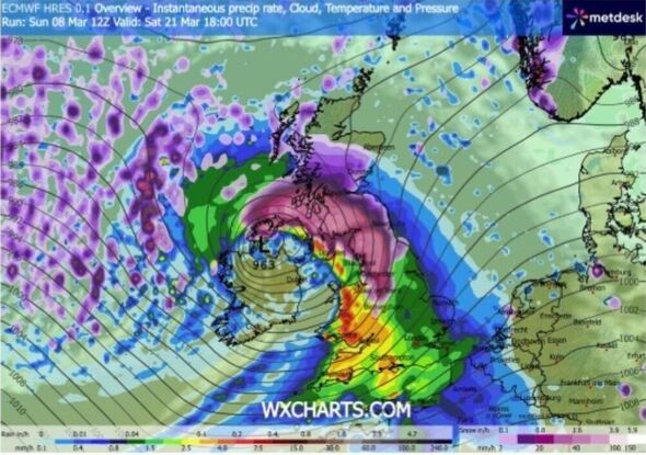
Almost the whole of the British Isles looks set to be battered by snow and rain later this month, weather maps suggest. Forecast data collected by WXCHARTS.COM shows snow and rain clouds beginning to spread across the UK from the start of Thursday, March 19.
By 6pm on Saturday, March 21, almost the whole of Scotland will be seeing active snowfall or snow on the ground, save for the northernmost parts of the Highlands and the northeast. Affected areas include major cities like Edinburgh, Glasgow, Dundee, and Sterling, which could be seeing active snowfall at this time, the maps suggest. That snowcloud is shown stretching 418 miles from Wester Ross in the Northwest Highlands down through northern England down south as far as Worcester in the West Midlands, covering major cities like Newcastle, Manchester, Leeds, Newcastle, and others.
The rest of England and Wales is shown under rainclouds, as is Northern Ireland, which could also see some active snowfall in northern areas, the maps suggest.
They indicate snow and rain could continue in different parts of the UK until at least Monday, March 23.
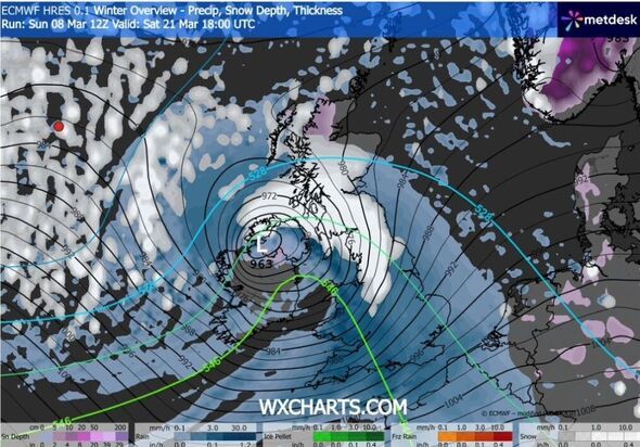
At midday that day, parts of the highlands could be seeing as much as 45cm of snow, while southern Scotland could see as much as 29cm. Snow depths in England look set to range between 1 and 19cm in the northwest. Snow depth could range between 1 and 10cm, while in Northern Ireland it could be between 2 and 14cm.
Snow could have struck as far south as Cornwall by this time.
However, snow is notoriously difficult to predict, so it's best to check the Met Office forecasts and see if any warnings or guidance have been issued closer to the time.
The national weather agency's long-range forecast, providing the outlook for Friday, March 13 to Sunday, March 22, anticipates conditions will be changeable "through much of this period, as Atlantic frontal systems pass close to or across the UK at times".
"These will bring some occasional spells of rain or showers, most frequent in the west and northwest, and perhaps accompanied by strong winds.
"However, there should also be some drier interludes under transient ridges of high pressure, with longer dry periods most likely in the south and east, though even here some wet weather is likely at times.
*** Ensure our latest news headlines always appear at the top of your Google Search by making us a Preferred Source. Click here to activate or add us as Preferred Source in your Google search settings. ***
"Temperatures will be near-average for the period as a whole, but with some shorter-duration colder interludes at times when frost and hill snow will be possible.
It adds: "Later in the period, there may be a transition to more blocked or slower evolving weather patterns, though confidence in the detail of this is rather low."
Meanwhile, the outlook for Monday, March 23 to Monday, April 6 suggests more blocked, "or slowly evolving, weather patterns are favoured for late March into early April, with high pressure probably building to the north of the UK".
"Whilst confidence is rather low in how this will influence the weather across the UK, this tends to lead to a more prolonged period of a certain weather type, be it settled or unsettled," the national weather agency says.
"In any case, a reduction in Atlantic-dominated weather patterns is favoured, although some wet weather remains possible at times, more especially in the south and east whilst northwestern areas tend to be drier than average.
"Temperatures will probably be close to average for the period as a whole, but there is an increased chance of some colder conditions developing for a time with a risk of frost."
-
Crude Oil Prices Drop Over 6% as Hopes Rise for Easing Middle East Tensions

-
Petrol and Diesel Prices Today: Check Latest Fuel Rates in Major Indian Cities

-
Gold Prices Slip Again Despite War Tensions; Check 24K, 22K and 18K Rates in 10 Major Cities

-
Commercial LPG Supply Curtailed: Cylinders Now Reserved for Hospitals and Schools

-
PPF, NPS or Sukanya Samriddhi Account Holders Alert: Complete This Mandatory Task Before March 31 to Keep Your Account Active