Which plateau is known as the Roof of India: The incredible high-altitude world hidden in Ladakh
ETimes | June 30, 2026 4:40 PM CST
There is a point in northern India where the landscape changes so completely that familiar mountain scenery gives way to an immense world of open plains, wind-shaped valleys and silent lakes. This is Ladakh, home to one of the country's most remarkable high-altitude regions. The area sits among the Himalaya and the Karakoram, yet much of it resembles a vast plateau rather than a chain of towering peaks. Its thin air, sparse vegetation and wide horizons have earned it comparisons with Tibet for generations.
The phrase " Roof of India " is often used to describe this elevated land, reflecting both its height and its distinctive geography. Beyond the dramatic scenery, the plateau supports rare wildlife, ancient settlements and fragile wetlands that survive in one of the harshest environments found anywhere in the Indian subcontinent.
Why Changthang is known as the Roof of India
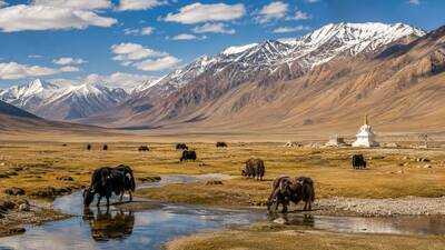
The Changthang Plateau in eastern Ladakh is widely recognised as the plateau called the Roof of India. Stretching across India's northern frontier before continuing into the Tibetan Plateau, it occupies some of the country's highest inhabited terrain. Much of the landscape lies between 4,000 and 5,500 metres above sea level, where oxygen levels are significantly lower than those experienced in the plains.
Unlike the steep valleys often associated with the Himalaya, Changthang consists of broad open basins separated by rugged mountain ranges. These high plains appear almost endless, interrupted only by lakes, marshes and isolated grazing grounds. Its altitude has shaped every aspect of life, from the movement of wildlife to the traditions of the nomadic communities who have lived here for centuries.
How the Himalaya turned Changthang into a cold desert
Although surrounded by snow-covered mountains, Changthang receives surprisingly little rainfall. The Himalaya block much of the moisture carried by monsoon winds, leaving this region within a rain-shadow zone. As a result, it is classified as a cold desert.
Winters are exceptionally long and severe. Heavy snowfall often cuts off roads for months, while temperatures regularly plunge far below freezing. Summer brings only a brief growing season before cold conditions return. Even during warmer months, daytime warmth can quickly disappear after sunset, creating dramatic shifts in temperature within a matter of hours.
This demanding climate has produced an ecosystem that depends on meltwater from glaciers, seasonal streams and natural springs rather than regular rainfall.
How Pangong Tso, Tso Moriri and Tso Kar shape Changthang
Some of India's highest lakes lie within the Changthang Plateau, giving the region much of its ecological importance.
Pangong Tso is perhaps the most widely recognised. Sitting at around 4,350 metres above sea level, this long saline lake stretches across the international border into Tibet. Despite containing salty water, it freezes completely during winter. Sparse vegetation lines sections of its shore, yet it provides breeding habitat for several waterbird species each summer.
Further south lies Tso Moriri, India's largest high-altitude lake located entirely within Indian territory. Fed mainly by snowmelt and underground springs, it supports extensive marshes around its edges where grasses grow during the short summer season.
Nearby, the Tso Kar wetland presents an unusual natural arrangement. Tso Kar itself is saline, while the neighbouring Startsapuk Tso contains fresh water. A connecting channel links the two lakes, creating varied habitats that attract birds and mammals throughout the breeding season.
The remarkable animals of the Changthang Plateau
Life survives here because it has evolved to cope with conditions that would challenge most animals elsewhere.
Kiangs, the wild asses of the Tibetan Plateau, roam open grasslands feeding on sedges and alpine meadow plants. Tibetan gazelles move across the landscape in search of grazing, while blue sheep occupy rocky slopes overlooking the valleys.
Himalayan marmots spend much of the warmer months feeding before retreating into extensive burrow systems during winter hibernation. Small mammals such as silver voles also form an important part of the plateau's food web, supporting predators including Tibetan wolves, foxes and birds of prey.
Among the smaller birds, species such as Little Owls, Tibetan Partridges, wheatears and finches are well suited to the dry, open terrain, making use of rocky outcrops and scattered vegetation for shelter.
Why birds depend on these wetlands
Changthang's lakes and marshes become especially important during the breeding season. Waterbirds arrive each summer to nest around shallow wetlands before beginning long migrations later in the year.
Bar-headed Geese, famous for crossing the Himalaya during migration, regularly breed around these lakes alongside Ruddy Shelducks, Brown-headed Gulls, Common Terns and Great Crested Grebes.
The wetlands also provide feeding grounds for waders and ducks, while quieter marshes near rivers support species that require undisturbed nesting sites. The combination of freshwater pools, saline lakes and seasonal grasslands creates an unusually diverse network of habitats within an otherwise arid landscape.
Life on the plateau
Permanent settlements are few across Changthang. Many residents continue to follow a traditional nomadic lifestyle, moving livestock between seasonal grazing grounds as weather conditions change.
Villages remain widely separated, connected by roads that often pass through mountain passes exceeding 5,000 metres in elevation. During periods of heavy snowfall or landslides, travel may become impossible for days or even weeks.
The region is also home to centuries-old monasteries, military outposts and isolated agricultural fields that depend almost entirely on meltwater from surrounding mountains.
How to reach Changthang Plateau (Ladakh, India)
The phrase " Roof of India " is often used to describe this elevated land, reflecting both its height and its distinctive geography. Beyond the dramatic scenery, the plateau supports rare wildlife, ancient settlements and fragile wetlands that survive in one of the harshest environments found anywhere in the Indian subcontinent.
Why Changthang is known as the Roof of India
The Changthang Plateau in eastern Ladakh is widely recognised as the plateau called the Roof of India. Stretching across India's northern frontier before continuing into the Tibetan Plateau, it occupies some of the country's highest inhabited terrain. Much of the landscape lies between 4,000 and 5,500 metres above sea level, where oxygen levels are significantly lower than those experienced in the plains.
Unlike the steep valleys often associated with the Himalaya, Changthang consists of broad open basins separated by rugged mountain ranges. These high plains appear almost endless, interrupted only by lakes, marshes and isolated grazing grounds. Its altitude has shaped every aspect of life, from the movement of wildlife to the traditions of the nomadic communities who have lived here for centuries.
How the Himalaya turned Changthang into a cold desert
Although surrounded by snow-covered mountains, Changthang receives surprisingly little rainfall. The Himalaya block much of the moisture carried by monsoon winds, leaving this region within a rain-shadow zone. As a result, it is classified as a cold desert.
Winters are exceptionally long and severe. Heavy snowfall often cuts off roads for months, while temperatures regularly plunge far below freezing. Summer brings only a brief growing season before cold conditions return. Even during warmer months, daytime warmth can quickly disappear after sunset, creating dramatic shifts in temperature within a matter of hours.
This demanding climate has produced an ecosystem that depends on meltwater from glaciers, seasonal streams and natural springs rather than regular rainfall.
How Pangong Tso, Tso Moriri and Tso Kar shape Changthang
Some of India's highest lakes lie within the Changthang Plateau, giving the region much of its ecological importance.
Pangong Tso is perhaps the most widely recognised. Sitting at around 4,350 metres above sea level, this long saline lake stretches across the international border into Tibet. Despite containing salty water, it freezes completely during winter. Sparse vegetation lines sections of its shore, yet it provides breeding habitat for several waterbird species each summer.
Further south lies Tso Moriri, India's largest high-altitude lake located entirely within Indian territory. Fed mainly by snowmelt and underground springs, it supports extensive marshes around its edges where grasses grow during the short summer season.
Nearby, the Tso Kar wetland presents an unusual natural arrangement. Tso Kar itself is saline, while the neighbouring Startsapuk Tso contains fresh water. A connecting channel links the two lakes, creating varied habitats that attract birds and mammals throughout the breeding season.
The remarkable animals of the Changthang Plateau
Life survives here because it has evolved to cope with conditions that would challenge most animals elsewhere.
Kiangs, the wild asses of the Tibetan Plateau, roam open grasslands feeding on sedges and alpine meadow plants. Tibetan gazelles move across the landscape in search of grazing, while blue sheep occupy rocky slopes overlooking the valleys.
Himalayan marmots spend much of the warmer months feeding before retreating into extensive burrow systems during winter hibernation. Small mammals such as silver voles also form an important part of the plateau's food web, supporting predators including Tibetan wolves, foxes and birds of prey.
Among the smaller birds, species such as Little Owls, Tibetan Partridges, wheatears and finches are well suited to the dry, open terrain, making use of rocky outcrops and scattered vegetation for shelter.
Why birds depend on these wetlands
Changthang's lakes and marshes become especially important during the breeding season. Waterbirds arrive each summer to nest around shallow wetlands before beginning long migrations later in the year.
Bar-headed Geese, famous for crossing the Himalaya during migration, regularly breed around these lakes alongside Ruddy Shelducks, Brown-headed Gulls, Common Terns and Great Crested Grebes.
The wetlands also provide feeding grounds for waders and ducks, while quieter marshes near rivers support species that require undisturbed nesting sites. The combination of freshwater pools, saline lakes and seasonal grasslands creates an unusually diverse network of habitats within an otherwise arid landscape.
Life on the plateau
Permanent settlements are few across Changthang. Many residents continue to follow a traditional nomadic lifestyle, moving livestock between seasonal grazing grounds as weather conditions change.
Villages remain widely separated, connected by roads that often pass through mountain passes exceeding 5,000 metres in elevation. During periods of heavy snowfall or landslides, travel may become impossible for days or even weeks.
The region is also home to centuries-old monasteries, military outposts and isolated agricultural fields that depend almost entirely on meltwater from surrounding mountains.
How to reach Changthang Plateau (Ladakh, India)
- Reach Leh first by flight or by road.
- Acclimatise in Leh for at least 24–48 hours to avoid altitude sickness before going further.
- Get required permits: Inner Line Permit (ILP) for Indian citizens; additional restricted permits may be needed for some areas.
- Start road journey from Leh towards Changthang Plateau via Karu and Chang La pass.
- Common route: Leh → Karu → Chang La → Tangtse → Pangong Tso.
- For deeper Changthang exploration, continue beyond Pangong towards Nyoma, Loma, and Hanle.
- Expect long travel times (6–12+ hours depending on destination) and limited fuel/food stops.
- Best travel season is May to September when roads are open and weather is relatively stable.
- Carry warm clothing, water, medicines, and offline maps due to remote conditions.
- Check army checkpoints along the route and keep permits and ID ready at all times.
READ NEXT
-
Not only in cooking, but also under the pillow great performance bay leaves! Find out what benefits you will get

-
What is Night Tourism? Know why the new travel trend of night travel is growing rapidly

-
Tesla Supercharger Network Hits Record 60M Sessions: How V4 Hardware is Defying the Grid Crisis

-
Fear of cyber fraud in WhatsApp’s ‘username’ feature! What response to the center?

-
Airtel launches cheap plan of ₹ 200, 15+ OTT apps and 5G data will be available with 28 days validity